
Elevation 410 m Local time Saturday 7:59 PM Area code 01 | Post code 1223 Area 92 ha Population 101 (2002) | |
 | ||
Weather 9°C, Wind NW at 5 km/h, 95% Humidity | ||
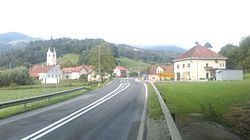
Blagovica ([blaˈɡoːʋitsa]; German: Glogowitz) is a village in the Municipality of Lukovica in the eastern part of the Upper Carniola region of Slovenia.
Map of 1223 Blagovica, Slovenia
Blagovica lies between the Radomlja River and Zlatenščica Creek and is the local center of the east-central part of the Radomlja Valley (also known as the Black Valley, Slovene: Črni graben) with a primary school, a post office, a bar, a gas station and a parish church. The village also has several organizations, including the Blagovica Volunteer Fire Department, the Blagovica Hiking Club, the Blagovica Cultural Society, the Blagovica Rural Youth Organisation, and the Trojane–Blagovica Rural Women's Society.
Blagovica is also the seat of the Parish of Blagovica and Blagovica Local Community, which was an independent municipality until 1959 but then became a part of the Municipality of Domžale. Since 1995 the community has been part of the Municipality of Lukovica.
The parish church in the settlement is dedicated to Saint Peter.