
Population 1,738 (2011 census) Postal code 2256 | Postcode(s) 2256 Area 120 ha Parish Patonga | |
 | ||
Location 15 km (9 mi) S of Gosford3 km (2 mi) SSE of Woy Woy81 km (50 mi) from Sydney | ||
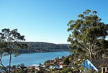
Blackwall is a suburb of the Central Coast region of New South Wales, Australia, south of Woy Woy on Brisbane Water, 81 kilometres (50 mi) north of the Sydney CBD. It is part of the Central Coast Council local government area.
Map of Blackwall NSW 2256, Australia
The suburb includes a boat ramp and a bushland recreation reserve, Kitchener Reserve, offering walk trails and views from Blackwall Mountain. The section of the suburb east of Kitchener Park is locally known as Orange Grove.
References
Blackwall, New South Wales Wikipedia(Text) CC BY-SA