
Country Albania Length 25 km | River mouth Ionian Sea Source elevation 180 m | |
 | ||
Discharge Average rate:40.4–66.4 m/s (1,430–2,340 cu ft/s) (August–Winter) | ||
Bistricë (definite: Bistrica) is a river in southwestern Albania. It ends in the Ionian Sea.
Contents
Geography
Bistricë starts from Mali i Gjerë (also known as Sopot) in Finiq municipality directing initially versus south-west. The main source is near Krongj ("The Blue Eye" source), also gathering other sources from the nearby villages of Pecë, Kardhikaq, Velahovë, and other smaller brooks. It passes through Mesopotam and Finiq municipalities, parallel with the Sarandë-Gjirokastër road.
Initially the river ended in Lake Butrint, which connects with the Ionian sea through the Vivar channel. In 1958, it was deviated to Çukë channel.
The river is 25 km long.
Economy and tourism
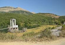
The river is not navigable. There is an artificial lake with the same name (Albanian: Liqeni i Bistricës) built on its basin, and three hydro-power stations built in the '60. The river's waters are used to a certain extent as a supply for the nearby fields of Vurg area. All the stations passed through the privatization process from 2010 with plenty of controversies.
A well known touristic place is the "Azure Eye", often referred as "Blue Eye" (Albanian: Syri i Kaltër), a spring tributary to Bistrica river near the village named Krongj, with a rich flora and fauna.