Rahul Sharma (Editor)

Binga District

Updated on
Edit
Like
Comment
Share on FacebookTweet on TwitterShare on LinkedInShare on Reddit
Local time
  
Thursday 5:07 AM

Binga District

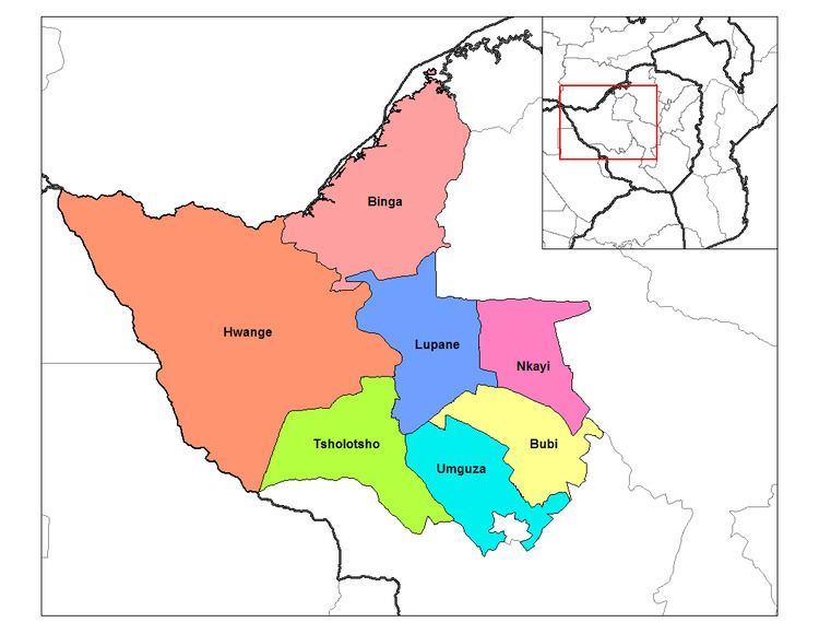
Binga District (Vinga District) is a district of Zimbabwe in southern Africa. It is located in Matabeleland North just south of Kariba Lake, across the lake from Zambia It lies along the hot and arid southern Zambezi Escarpment, a region that is in the territory of the tsetse fly, which transmits human sleeping sickness and animal trypanosomiasis.

Contents

Map of Binga, Zimbabwe

Boundaries

Binga District is an area of land bounded by a line drawn from;

  • a point on the Zimbabwe-Zambia international boundary at map reference 35KPM098348 on the 1:50 000 Map Sengwa Sound 1628C3, Edition 2, southwards direct to a point on the former Sengwa River course at map reference 35KPM114145 on the 1:50 000 Map Chiwa 1728A1, Edition 2;
  • thence proceeding generally southwards up the Sengwa River to the eastern boundary of Chizarira National Park,
  • thence generally southwest-wards along the eastern boundaries of Chizarira National Park and Busi Communal Land and westwards along the south- eastern boundary of Dandanda Communal Land;
  • thence generally westwards along the boundaries of Dandanda Communal Land to its westernmost point;
  • thence southwards along the westernmost boundary of Dandanda Communal land; thence eastwards along the northern boundary of Lubimbi Communal land up to the northernmost beacon of remainder of Lot 4 Karna Block;
  • thence generally south-westwards along the northern-western boundaries of Remainder of Lot 4 Karna Block and Lot 7A Karna Block up the westernmost beacon of Lot 7 A Karna Block;
  • thence proceeding generally westwards along the northern boundaries of Lot 8 Karna Block and the Remainder of Karna Block to exclude them up the intersection by the Shangani River;
  • thence up the Shangani River to a point at a map reference 35KNK259556 on the 1:50 000 Map Kamativi 1827A3, edition 1,
  • thence proceeding generally north-westwards to a point at map reference 35KNK249563 on the 1: 50 000 Map Kamativi 1827A3, Edition 1;
  • thence proceeding generally northwards along the western and north-western boundaries of Lubimbi Communal Land to a point at map reference 35KNK315618 on the 1:50 000 Map Kamativi 1827A3, Edition 1;
  • thence generally north-westwards along the south-western and western boundaries of Manjolo Communal Land to the southern boundary of Kavira Forest Land,
  • thence westwards along the southern boundary of Kavira Forest Land to the Gwayi River,
  • thence generally northwards down the Gwayi River to the Zimbabwe-Zambia international boundary;
  • thence north-eastwards along the Zimbabwe- Zambia international boundary to the starting point.
  • Administrave divisions and constituencies

    There are twenty-one wards in the district, which is divided into two parliamentary constituencies: Binga North Constituency with twelve wards and South Binga Constituency with nine wards. The separate constituencies were created in 2008.

    Among the areas in Binga North Constituency are: Chizarira, Siabuwa, Cheete, Siansundu, Siantula, Mujere and Manjolo.

    Settlements

    Binga village is by far one of the largest settlement. It lies on the south eastern shore of Lake Kariba. It was constructed to rehouse the BaTonga people whose homeland was flooded by the creation of the Kariba reservoir. The Chibwatatata Hot Springs lie near the town. There are also settlements at:

    Economy and development

    Binga District is one of the outposts of Zimbabwe that is underdeveloped, with limited access roads, especially during the rain season. It is also one of the most sparsely populated districts of the country.

    The consumption of cannabis in the Binga District has been described as traditional in pre-colonial times, and is considered to be an integral part of the Tonga culture. However, it must be pointed out that consumption of cannabis is generally considered a devious pursuit especially in light of colonial Laws DANGEROUS DRUGS ACT, CAP 15:02 (Zimbabwe) to control the importation, exportation, production, possession, sale, distribution and use of dangerous drugs. There is a wrong impression among people from the rest of Zimbabwe that people from Binga are legally entitled to plant, harvest, process and smoke cannabis freely

    References

    Binga District Wikipedia