
 | ||
The Big Bend region of Florida, United States, is an informal region of the state with no official surveyed boundary. It generally includes the counties of the Florida Panhandle east of the Apalachicola River. The Big Bend Coast is the marshy coast without barrier islands that extends along the Gulf of Mexico coast of Florida from the Ocklockonee River to Anclote Key.
Private agencies that self-identify as serving the Big Bend region often include Franklin, Gadsden, Jefferson, Leon, Liberty, Madison, Taylor and Wakulla counties in their service areas. The principal city in the region is Tallahassee.
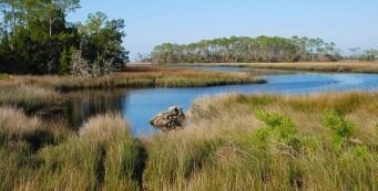
The Big Bend Coast is the marshy coast extending about 350 kilometres (220 mi) from the mouth of the Ocklockonee River around Apalachee Bay and down the west coast of peninsular Florida to Anclote Key. This stretch of coast includes the coasts of Wakulla, Jefferson, Taylor, Dixie, Levy, Citrus, Hernando and Pasco counties. The Big Bend Coast is a drowned karst region, covered with salt marsh. It includes freshwater springs, oyster reefs, and the delta of the Suwannee River. There are barrier islands west of the Oklockonee River and south starting with Anclote Key, but there are no barrier islands between those places. The Big Bend Coast has little or no sand or mud. The karst topography has produced an irregular, frequently exposed, bedrock surface. Due to the width of the adjacent continental shelf (over 150 kilometres (93 mi)), low gradient slope of the coast (1:5000), and shelter from the usual wind direction of storms, the Big Bend Coast is generally subject to low wave energy. The coast is subject to storm surges.