
Named for William W. Bibb Congressional district 6th Website www.bibbal.com Founded 1818 | Area 1,621 km² Population 22,512 (2013) Unemployment rate 5.9% (Apr 2015) | |
 | ||
Rivers Mahan Creek, Cahaba River, Mayberry Creek | ||
Help bibb county alabama traffic speeding ticket lawyer best bibb county al traffic attorney
Bibb County is a county in the U.S. state of Alabama. As of the 23rd Decennial 2010 United States Census its population was 22,915. The county seat is Centreville. Its name is in honor of William W. Bibb, (1781-1820), the Governor of Alabama Territory, (1817-1819), and the first Governor of Alabama, (1819-1820, when he died), who is also the namesake for Bibb County, Georgia where he began his political career. It is a "prohibition" or dry county; however, the cities of West Blocton, Brent, and Centreville have all become "wet", by allowing the sale of alcoholic beverages.
Contents
- Help bibb county alabama traffic speeding ticket lawyer best bibb county al traffic attorney
- Map of Bibb County AL USA
- Bibb county alabama reckless driving attorney lawyer for bibb county al reckless driving
- History
- Geography
- Adjacent counties
- National protected areas
- Major highways
- Rail
- Demographics
- Government and infrastructure
- Cities
- Towns
- Ghost towns
- Places of interest
- References
Map of Bibb County, AL, USA
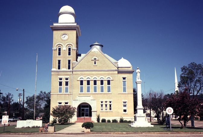
The Bibb County Courthouse is located in the county seat of Centreville.
Bibb county alabama reckless driving attorney lawyer for bibb county al reckless driving
History
Cahawba County was established ("erected") on February 7, 1818, named for the Cahawba River, (now more commonly spelled as Cahaba River). This name came from the Choctaw language word meaning "water above." On December 4, 1820, it was renamed as Bibb County.
With a large population of slaves before the American Civil War, during and after Reconstruction whites worked to dominate and establish white supremacy. In addition to laws that the state legislature passed, creating a new constitution that raised barriers to voter registration and excluding freedmen from the political process, this county ranked with two others: Dallas and Pickens, as having the third-highest number of lynchings in the state. These extrajudicial murders were a form of racial terrorism by the whites against blacks.
Geography
According to the U.S. Census Bureau, the county has a total area of 626 square miles (1,620 km2), of which 623 square miles (1,610 km2) is land and 3.6 square miles (9.3 km2) (0.6%) is water.
Adjacent counties
National protected areas
Major highways
Rail
Demographics
From 1920 to 1970, the population of the rural county declined considerably. Many African Americans joined the Great Migration to northern and western cities, to escape the violence and racial oppression of Jim Crow.
As of the census of 2010, there were 22,915 people, 7,953 households, and 5,748 families residing in the county. The population density was 37 people per square mile (14/km2). There were 8,981 housing units at an average density of 14.3 per square mile (5.5/km2). The racial makeup of the county was 75.8% White, 22.0% Black or African American, 0.3% Native American, 0.1% Asian, 0.1% Pacific Islander, 0.8% from other races, and 0.9% from two or more races. 1.8% of the population were Hispanic or Latino of any race.
There were 7,953 households out of which 29.5% had children under the age of 18 living with them, 52.5% were married couples living together, 14.4% had a female householder with no husband present, and 27.7% were non-families. 24.5% of all households were made up of individuals and 9.40% had someone living alone who was 65 years of age or older. The average household size was 2.60 and the average family size was 3.09.
In the county, the population was spread out with 22.7% under the age of 18, 9.0% from 18 to 24, 28.9% from 25 to 44, 26.7% from 45 to 64, and 12.7% who were 65 years of age or older. The median age was 37.8 years. For every 100 females there were 115.9 males. For every 100 females age 18 and over, there were 127.5 males.
The median income for a household in the county was $41,770, and the median income for a family was $51,956. Males had a median income of $40,219 versus $28,085 for females. The per capita income for the county was $19,918. About 9.4% of families and 12.6% of the population were below the poverty line, including 18.4% of those under age 18 and 11.3% of those age 65 or over.
Government and infrastructure
Bibb County has a five-member County Commission, elected from single-member districts. Members take turns in serving as chairman of the commission, rotating the position every nine and a half months.
Alabama Department of Corrections operates the Bibb Correctional Facility in Brent.
Cities
Towns
Ghost towns
Places of interest
Bibb County is home to the Talladega National Forest supervised by the United States Forestry Service (of the U.S. Department of Agriculture), and a section of the Cahaba River which draws visitors to view the unique "Cahaba Lily", or (known by its scientific Latinized name: Hymenocallis coronaria).