
Highest elevation 725 m (2,379 ft) Population 2,200 Local time Wednesday 6:39 AM | Lowest elevation 650 m (2,130 ft) | |
 | ||
Country Poland93.178.252.244:8080 Weather 3°C, Wind W at 11 km/h, 89% Humidity Points of interest Terma Bania, Białka Tatrzańska ‑ Kotelnica, Stacja Narciarska Kaniówka, Białka Tatrzańska ‑ Kaniówka, Park linowy Tatry | ||
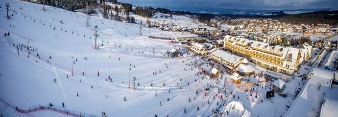
Bia ka tatrza ska kotelnica snowboard 2014 gopro capital cities
Bialkka Tatrzanska [ˈbjau̯ka taˈtʂaɲska] is a village in the administrative district of Gmina Bukowina Tatrzańska, within Tatra County, Lesser Poland Voivodeship, in southern Poland, close to the border with Slovakia. It lies approximately 6 kilometres (4 mi) north of Bukowina Tatrzańska, 16 km (10 mi) north-east of Zakopane, and 75 km (47 mi) south of the regional capital Kraków.
Contents
- Bia ka tatrza ska kotelnica snowboard 2014 gopro capital cities
- Map of BiaC582ka TatrzaC584ska Poland
- References
Map of Bia%C5%82ka Tatrza%C5%84ska, Poland
The village has a population of 2,200. A skiing center in the village attracts many tourists and has improved the economy of the area. Many residents have created chalets and bed and breakfast facilities to accommodate skiers.
References
Białka Tatrzańska Wikipedia(Text) CC BY-SA