
- elevation 1,755 m (5,758 ft) Basin area 11,800 km² | - right Kamoro River Length 525 km | |
 | ||
- location | ||
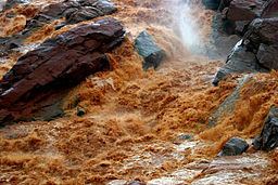
Betsiboka River is a 525-kilometre (326 mi) long river in central-north Madagascar. It flows northwestward and empties to Bombetoka Bay, forming a large delta. It originates to the east of Antananarivo. The river is surrounded in mangroves. The river is distinct for its red-coloured water, which is caused by river sediments. The river carries an enormous amount of reddish-orange silt to the sea. Much of this silt is deposited at the mouth of the river or in the bay.
Map of Betsiboka, Madagascar
It is dramatic evidence of the catastrophic erosion of northwestern Madagascar. Removal of the native forest for cultivation and pastureland during the past 50 years has led to massive annual soil losses approaching 250 metric tonnes per hectare (112 tons per acre) in some regions of the island, the largest amount recorded anywhere in the world. Several fish species are endemic to the river basin, including the three cichlids Paretroplus petiti, P. tsimoly and P. maculatus.
The Betsiboka's largest tributary, the Ikopa River, drains the capital city of Antananarivo.