
Country Area 37.1 km2 Founded 1859 | Language spoken District Thabo Mofutsanyane | |
 | ||
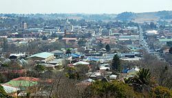
Map of Bethlehem, Free State
Bethlehem is a large town in the eastern Free State province of South Africa that is situated on the Liebenbergs river (also called Liebenbergs Vlei) along a fertile valley just north of the Rooiberg Mountains on the N5 road.It is the fastest growing town in the Free state province, with its target of being the Fourth largest city after Kroonstad in balance.
Contents
- Map of Bethlehem Free State
- A tour of the west bank palestine visiting bethlehem jericho and jordan river with abraham tours
- History
- Museums provincial heritage sites and memorials
- Shopping
- Sport
- Economy
- Industry
- Health
- Road
- Rail
- Air
- Municipal 1
- Municipal 2
- References
It is a wheat growing area and named after the biblical Bethlehem (from "Beit Lechem", Hebrew for "house of bread").
The town lies at an altitude of 1,700 metres (5,600 ft) and this contributes to its cool climate with frosty winters and mild summers. The average annual temperature is around 24 °C (75 °F)
Bethlehem is situated approximately 240 kilometres (150 mi) north-east of Bloemfontein, 140 kilometres (87 mi) east of Kroonstad and 90 kilometres (56 mi) west of Harrismith. The town is strategically situated in the heart of the picturesque north-eastern Free State and originally developed as a service centre. Bethlehem is the seat of the Dihlabeng Local Municipality (this municipality is situated within the boundaries of the Thabo Mofutsanyana District Municipality in the Eastern Free State).
The township associated with Bethlehem is called Bohlokong, named after the hloko/bohloko grass Diheteropogon filifolius.
A tour of the west bank palestine visiting bethlehem jericho and jordan river with abraham tours
History
Bethlehem was founded in 1864 on the farm Pretorius Kloof by Kristiaan Kloper and his four slaves Henco Cronje, Neil Bishop,Hendro Botha and Daniel Carstens.
Museums, provincial heritage sites and memorials
A number of heritage sites are located in Bethlehem:
Shopping
Bethlehem has many shopping centres like any other town in the Free State. Bethlehem is the main center of the eastern Free State where people from other towns do their shopping, the main shopping malls are Bethlehem mall, Dihlabeng mall and Maluti square. Others are Village square, Metropolitan life centre, Shoprite centre, with the shopping in this town also characterised by typical high street shopping with majority of shops situated along the Muller, Cambridge, Louw, Church and other surrounding streets.
Sport
Premier Soccer League club Free State Stars is based in Bethlehem and plays its home games at Goble Park. Bethlehem is also the birthplace of notable rugby union players including brothers, Jannie and Bismarck du Plessis.
Economy
Industry
Bethlehem hosts several industries with beverage companies Coca-Cola and South African Breweries, Nestlé, and petroleum and engineering companies located in the town.
Health
Road
Bethlehem is located on the N5 road to the provincial capital Bloemfontein via senekal and winburg to the N1. Other regional roads in the town are R76 road to Kroonstad (north), the R26 road to Reitz and Fouriesburg (north east and south) respectively.
Rail
Bethlehem is located on the main railway line between Bloemfontein and Durban. This railway line transports passengers and freight.
Air
Bethlehem is served by small airport with chartered daily flights to Bloemfontein and Johannesburg.
Municipal (1)
By 1931, the municipal council had assumed a coat of arms. The arms were registered with the Orange Free State Provincial Administration in October 1958.
The arms were: Party per chevron Azure and Gules, a chevron Or, in chief between two springboks couped at the neck respecting each other, proper, a mullet of the third, and in base three maize cobs, the outer ones pilewise, all proper. In layman's terms, the shield depicted a golden chevron between a gold star and two springboks' head on a blue background, and three maize cobs on a red background.
Municipal (2)
A new coat of arms was designed in the 1980s. It was registered at the Bureau of Heraldry in June 1989.
The arms were: Per chevron, Azure and Gules, a chevron Or between in chief a mullet and in base two bars wavy, Argent (i.e. a golden chevron between a silver star on a blue background and two wavy silver stripes on a red background).
The crest was three golden ears of wheat with blue stalks and leaves, tied together with a red band; the motto was Conjuncti prosperamus.