
Country United States County Gogebic FIPS code 26-07960 Elevation 434 m Zip code 49911 Local time Sunday 1:25 PM | Time zone Central (CST) (UTC-6) GNIS feature ID 0621184 Area 14.17 km² Population 1,835 (2013) Area code 906 | |
 | ||
Weather 5°C, Wind S at 21 km/h, 66% Humidity | ||
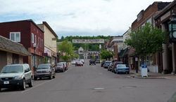
Bessemer is a city in the U.S. state of Michigan. As of the 2010 census, the city population was 1,914. It is the county seat of Gogebic County.
Contents
- Map of Bessemer MI 49911 USA
- History
- Government
- Geography
- Demographics
- 2010 census
- Newspapers
- Area Radio Station Coverage
- Local Television Station Coverage
- Notable people
- Transportation
- References
Map of Bessemer, MI 49911, USA
The city is situated within Bessemer Township, but is politically independent. It is on US 2 with Ironwood several miles to the west and Wakefield several miles to the east. The Big Powderhorn, Blackjack and Indianhead ski areas are located within a few miles of Bessemer. Cross-country skiing and snowmobiling are also very popular in this area because of heavy snowfall influenced by nearby Lake Superior and this area is often referred to as "Big Snow Country".
History
In 1880, a hunter and trapper Richard Langford, discovered iron ore under an overturned birch tree. However, Captain N. D. Moore is credited with disclosing the ore which led to the development of the Colby property. Mining began in 1883. By 1884, the Milwaukee Lake Shore and Western Railroad (later the Chicago and Northwestern) was being built from Antigo, WI to Ashland, WI by way of the new mines. The railroad company platted the town of Bessemer in 1884. On June 4, 1886 Gogebic County was separated from Ontonagon County. In March 1887, 360 voting members assembled and voted to organize the village of Bessemer. In the same year Gogebic County was officially created by the Michigan Legislature. Also in the year Bessemer and Ironwood called an election to see which city would be the county seat and also have the Gogebic County Courthouse. Ironwood men traveling to Bessemer to vote were made drunk and the train did not stop at the voting site. Ironwood lost and Bessemer gained the county seat. From 1884 to December 31, 1958, a period of seventy-five years, the iron ore shipment from all of Gogebic County totaled over 245 million tons. In 1966 the last mine in Bessemer-the Peterson Mine was closed. Many left the area to work in car factories in Kenosha, and the local economy underwent a serious decline.
Bessemer is named for Sir Henry Bessemer (1813-1898), English inventor of steel manufacturing.
Government
Bessemer is operated by an elected 5-member city council with day-to-day operations run by an appointed city manager. Staff also consists of administrative staff, public works department, and library staff. Bessemer also belongs to the Gogebic Range Water Authority.
City Council
City Manager
Geography
According to the United States Census Bureau, the city has a total area of 5.47 square miles (14.17 km2), all land. Majority of Bessemer is situated on the north side of Colby Hill and the city consists of many hills and valleys.
Demographics
As of 2000 the median income for a household in the city was $27,639, and the median income for a family was $36,739. Males had a median income of $28,958 versus $21,708 for females. The per capita income for the city was $17,499. About 8.6% of families and 12.1% of the population were below the poverty line, including 17.0% of those under age 18 and 7.9% of those age 65 or over.
2010 census
As of the census of 2010, there were 1,905 people, 888 households, and 511 families residing in the city. The population density was 348.3 inhabitants per square mile (134.5/km2). There were 1,140 housing units at an average density of 208.4 per square mile (80.5/km2). The racial makeup of the city was 96.4% White, 0.5% African American, 0.9% Native American, 0.3% Asian, 0.3% from other races, and 1.6% from two or more races. Hispanic or Latino of any race were 0.7% of the population.
There were 888 households of which 24.5% had children under the age of 18 living with them, 42.9% were married couples living together, 10.6% had a female householder with no husband present, 4.1% had a male householder with no wife present, and 42.5% were non-families. 38.3% of all households were made up of individuals and 19.4% had someone living alone who was 65 years of age or older. The average household size was 2.11 and the average family size was 2.76.
The median age in the city was 45.4 years. 20.3% of residents were under the age of 18; 9.1% were between the ages of 18 and 24; 20.1% were from 25 to 44; 29.5% were from 45 to 64; and 21% were 65 years of age or older. The gender makeup of the city was 49.1% male and 50.9% female.
Newspapers
Area Radio Station Coverage
Local Television Station Coverage
Notable people
Transportation
Indian Trails provides daily intercity bus service between St. Ignace and Ironwood, while Gogebic County operates a small public bus system, the Gogebic County Transit Authority.
Commercial air service is available at the Gogebic-Iron County Airport (IWD) north of Ironwood. Air Choice One operates flights from Ironwood to Chicago and from Chicago to Ironwood daily. Flights to and from Minneapolis will be added beginning June 1, 2016.