
Country France Department Puy-de-Dôme Intercommunality Haut-Livradois Area 24.31 km² Arrondissement Ambert | Region Auvergne-Rhône-Alpes Canton Les Monts du Livradois Population (2013) 467 Local time Sunday 1:32 AM | |
 | ||
Weather 2°C, Wind S at 8 km/h, 79% Humidity | ||
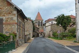
Bertignat is a commune in the Puy-de-Dôme department in Auvergne-Rhône-Alpes in central France.
Contents
Map of 63480 Bertignat, France
Geography
The commune is bordered along its eastern and northern limits by the river Dore, tributary of the river Allier.
Localities
Babylone, le Bateau, les Batisses, Boisset, le Bost de Dore, Bourdelles, le Bourg, Boutonnargue, la Brugière, la Cambuse, le Chalet, Champandelay, le Chassagnon, le Chassaing, Chatelet, Chaussadis, les Claustres, la Collange Basse, le Champ, la Collange Haute, le Combas, le Combat, Conche, Conchette, la Côte de Sauvanis, la Croix du Bost de Dore, Dousson, Espinasse, la Faye, Flouvat, Fonlupt, le Fraisse, la Garde, la Goutte, Goutte-Clos, le Grand Bost, Grand Pré, la Grange, Lenteyras, Malfriat, Mariaux, Marioux, Meaux, le Mas, la Mayoux, Monteilhet, les Moulins, le Perrier, le Petit Bost, Pierre Grosse, Piessat, les Plaines, les Pommerettes, Pont de David (à cheval sur la commune de la Chapelle-Agnon), Pradis, le Prat, Pubrière, le Puy, Puybayou, la Ravanie, la Raze, les Rochades, la Roche, le Roule, le Rourre, Sagne Vert, Sauvanis, les Thuis,
Administration
Since March 2008, the Mayor has been Claudette Imbault, a retired education official.
Sights
The parish church was classified as a historic monument in 1987. Notable are: a wayside cross in stone from the sixteenth century; and stone alcove of baptismal fonts from the last quarter of the fifteenth century.