
Route number 200.41200.42 | 36.90.0 Berlin-Moabit Locale Berlin | |
 | ||
Line number 6020 (S-Bahn)6170 (mainline) Track gauge 1,435 mm (4 ft 8 ⁄2 in) standard gauge Electrification S-Bahn: 750 V third railmain line: 15 kV/16.7 Hz AC Overhead catenary | ||
Berlin ringbahn circular railway in a berlin minute week 154 hd
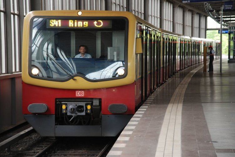
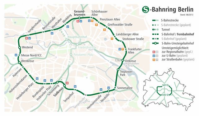
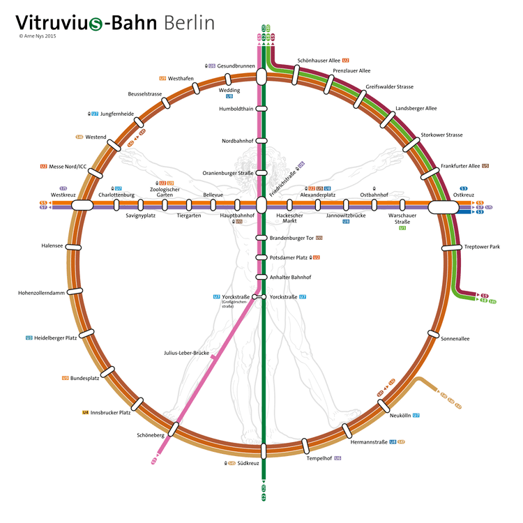
The Ringbahn (German for Circular Railway) is a 37.5 km (23.3 mi) long railway line of the Berlin S-Bahn network in Germany, around the city centre. The circle route is made up of the double tracked S-Bahn ring and the parallel freight ring. S-Bahn service on the line is provided by lines S 41 (clockwise) and S 42 (anticlockwise), carrying 400,000 passengers a day. Due to its distinctive shape, the line is often referred to as Hundekopf (Dog's Head).
Contents
- Berlin ringbahn circular railway in a berlin minute week 154 hd
- F hrerstandsmitfahrt s bahn berlin ringbahn s 41 ostkreuz ostkreuz
- Background
- Route
- The Berlin Wall division
- Reunification
- Services
- S Bahn
- Mainline
- References
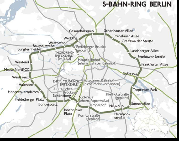
The Ring is structured by the east-west railway thoroughfare called the Stadtbahn (city railway), crossing the Ring in the west at Westkreuz and in the east at Ostkreuz (Eastern Crossing) into a Südring (Southern Ring) and a Nordring (Northern Ring), and by the north-south S-Bahn link (with the North-South S-Bahn-tunnel as its central part) crossing at Gesundbrunnen station in the north and both Schöneberg station and Südkreuz in the south into a Westring (Western Ring) and an Ostring (Eastern Ring). These four sections served as tariff zones of the railway Berlin suburban fare structure before the previous world war.
Today, the Ringbahn is the boundary of the "A" zone in the Verkehrsverbund Berlin-Brandenburg transport association's fare structure, and the road traffic control zone for the low emissions established on 1 January 2008.
F hrerstandsmitfahrt s bahn berlin ringbahn s 41 ostkreuz ostkreuz
Background
In 1851 the Königliche Bahnhofs-Verbindungsbahn (Royal Station Connection Railway) was completed between the termini of some railroads terminating in Berlin: initially the Stettiner Bahnhof and the Anhalter Bahnhof, but later to include the Schlesischer Bahnhof. It was laid in the streets, disrupting traffic and disturbing residents. In order to minimise disruption of traffic, trains ran at night, with the train bell being rung constantly.
Plans were soon developed to build a ring line primarily for freight, running outside the then city limits. Funding for construction was possible only after the victory in the war with Austria of 1866. The Lower Silesia-March [of Brandenburg] Railway Company was commissioned to construct and manage the line: construction began in 1867 and was completed in 1877.
Route
The first section opened on 17 July 1871 from Moabit through Gesundbrunnen, Central-Viehhof (now Storkower Straße), Stralau-Rummelsburg (now Ostkreuz), Rixdorf (now Neukölln) and Schöneberg (later Kolonnenstraße, at the side where there is the new Julius-Leber-Brücke) to Potsdamer ring station, an annex of Potsdamer station. From there, trains returned in the opposite direction. The line crossed the Anhalt Railway (and later the Royal Prussian Military Railway) on bridges.
With the opening of the section from Schöneberg through the still-independent city of Charlottenburg (now Westend station) to Moabit on 15 November 1877, the ring was complete for freight and long distance trains, while the suburban trains running on the Ring would still visit and reverse at Potsdamer station in the city centre, turning north from the ring, running in parallel to the Berlin–Potsdam–Magdeburg Railway. This section from the actual ring into the Potsdamer ring station became known as the Südringspitzkehre (Southern ring switchback or hairpin turn), reflecting the need for trains to reverse there to continue their trip around the ring. Passengers could change at the Kolonnenstraße station across the platform to continue to ride on the Ring without going all the way to the Potsdamer Ringbahnhof.
From 1 January 1872, freight was carried on the line to freight yards separate from the passenger stations. The line was electrified in 1926. In 1930, ring line operation was combined with the Stadtbahn and suburban services as the Berlin S-Bahn.
Since the trains were pulled by steam locomotives, they had to be refilled with water and coal and serviced at relatively short intervals; this was possible by reversing at Potsdamer Bahnhof. Even after electrification, the management of the railway company wanted to spare the passengers the need to change at the Papestraße or Schöneberg stations to an already well-filled train coming from the suburbs to reach the city centre. Originally, there were not even the necessary rails for continuing on the Ring between Schöneberg and Papestraße stations.
The Reichsbahn planned to replace the level crossings between the Ring and Südringspitzkehre by over- and underpasses together with the building of the north-south S-Bahn line in the late 1930s, but this was omitted as one of many planned changes after the proclamation of Hitler's Welthauptstadt Germania on 30 January 1937. In World War II, the Potsdamer and Anhalter stations were heavily bombed; the Südringspitzkehre was closed in 1944 and was never reopened.
The Berlin Wall division
From 1944 until the construction of the Berlin Wall in 1961, S-Bahn trains ran over the direct line between Papestraße (now Südkreuz) and Schöneberg opened in 1933, making a complete circle. With the building of the Wall, the line was broken in two places:
The building of the Berlin Wall in 1961 prevented continuous operation, after which passenger numbers on the West Berlin side, between Gesundbrunnen and Sonnenallee, declined. This was caused partly by a politically motivated call for a boycott, because revenue from the West Berlin S-Bahn, which was operated by East German railways, supported the East German government. The East Berlin section, from Schönhauser Allee to Treptower Park, remained in operation as it formed part of a major north-south tangent.
After the 1980 S-Bahn strike, service on the western part of the ring was suspended for about 13 years.
On 9 January 1984, a treaty between East Germany and the West Berlin Senate came into force and turned over responsibility for operation of the S-Bahn in West Berlin to the West Berlin transport authority BVG. It was initially planned to restore the section between Westend and Sonnenallee.
Reunification
After German reunification in 1990, plans were changed, so that in 1993 the south ring was reopened to the junction with the line towards Baumschulenweg with a connection to the Goerlitz line. The reconstruction of the connection between Sonnenallee and Treptow Park required large-scale renovation that was not feasible in the short term. The western part of the ring line was put back into operation in stages:
More than 12 years after the fall of the Wall, the last gap of the S-Bahn between Westhafen, Wedding and Gesundbrunnen, was fully restored on 16 June 2002. Promotional material for the reopening referred this as the "Wedding Day", an allusion to the English word wedding. Services operated under the "screw concept", trains entered the ring from the south at Neukölln and circled around it one and the half times, at the time the trip around the ring could not be achieved in less than 63 minutes.
Since 28 May 2006, circular service has been operated as lines S41 (clockwise) and S42 (anticlockwise). Trains take around 60 minutes, running every five minutes in peak hours and every ten minutes between the peaks, and in the evenings, using the greatly accelerated 481/482 series trains. Some sections of the ring are used by other lines. On the southern ring from the Görlitz line in the southeast, line S47 terminates at Hermannstraße, S46 at Westend and S45 at Berlin Südkreuz station, with some terminating at Bundesplatz. On the eastern section of the ring, lines S8, S85 and S9 operate between Schönhauser Allee and Treptower Park.
Services
Under what is called the "mushroom concept", the long-distance lines on the northern part of the ring for regional or long-distance services were rebuilt and electrified. On the ring line, regional and mainline services stop at Gesundbrunnen and regional services stop at Jungfernheide.
The majority of the former ring line freight yards have been closed down or dismantled. Part of the former freight inner ring between Neukölln and Tempelhof is still used for freight, with a depot at Berlin-Moabit. The freight line is closed in the vicinity of Südkreuz and Ostkreuz.
S-Bahn
Branches from the ring line are:
There are connecting curves between the ring line and the Stadtbahn at Ostkreuz and Westkreuz.
The Südringspitzkehre spur to Potsdamer Bahnhof was closed in 1944 due to war damage and never rebuilt. Its reconstruction is being considered in the planning options for line S21.
Mainline
The following long-distance and freight curves connect with the ring line: