
 | ||
Similar Bagley Icefield, Yahtse Glacier, Hubbard Glacier, Nabesna Glacier, Wrangell–St Elias National | ||
Alaska bering glacier field trip
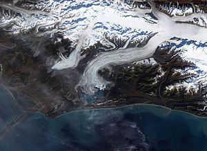
Bering Glacier is a glacier in the U.S. state of Alaska. It currently terminates in Vitus Lake south of Alaska’s Wrangell-St. Elias National Park, about 10 km (6.2 mi) from the Gulf of Alaska. Combined with the Bagley Icefield, where the snow that feeds the glacier accumulates, the Bering is the largest glacier in North America. Warmer temperatures and changes in precipitation over the past century have thinned the Bering Glacier by several hundred meters. Since 1900 the terminus has retreated as much as 12 km (7.5 mi). The Bering Glacier exhibits "surges", acceleration events of the flow rate of the glacier, every 20 years or so. During these periods the glacier terminus advances. The surges are generally followed by periods of retreat, so despite the periodic advances the glacier has been shrinking overall. Most glaciers along the Alaskan coast have been retreating along with the Bering Glacier.
Contents
Map of Bering Glacier, Alaska, USA
The glacial retreat has an interesting side effect, an increase in the frequency of earthquakes in the region. The Wrangell and St. Elias mountain ranges that spawn the Bering Glacier were created by the collision of the Pacific and North American tectonic plates [the Pacific Plate is sliding underneath (being subducted by) the North American Plate]. The weight of the vast amount of ice in the Bering Glacier is enough to depress the Earth's crust, stabilizing the boundary between the two plates. As the glaciers lose mass, the pressure of the ice is diminished. This reduced compression allows the rocks along faults to move more freely, resulting in more earthquakes.
Scientists from the Michigan Tech Research Institute, working with U.S. Geological Survey and U.S. Bureau of Land Management have recently discovered that the glacier is releasing approximately 30 cubic kilometres (7.2 cu mi) of water a year, more than twice the amount of water in the entire Colorado River.
Meltwater at the terminus collects in Vitus Lake, which flows via the Seal River to the Gulf of Alaska.