
Time zone EET (UTC+2) | Capital Zahlé Area 4,429 km² | |
 | ||
Points of interest Temple of Bacchus, Château Ksara, Baalbek Roman Ruins, Stone of the Pregnant, Baalbeck Temple Destinations Baalbek, Zahlé, Anjar, Hermel, Baalbek District | ||
Beqaa (Arabic: البقاع Al-Biqā') is a governorate in Lebanon with a population of 750,000 inhabitants.
Contents
Map of Beqaa Governorate, Lebanon
Geography
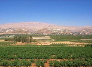
Beqaa Governorate lies in the Beqaa Valley between the Mount Lebanon and Anti-Lebanon mountain ranges and covers an area of 4,429 km². Beqaa Valley is the primary center of Lebanon's agriculture. The Litani River and Asi River run through the alley.
Climate and tourism
The temperature ranges from -10 °C to 35 °C throughout the year. Beqaa receives heavy rain and snow during the winter.
The villages of Zahlé, Machgara, Niha, Anjar, Qab Elias, Kfar Zabad, Karaon Dam, Chtaura, and Furzul are the area's main tourism destinations. Beqaa Governorate lies on an ancient route between Lebanon, Syria, and the rest of the Arab world. The governorate is known for its wine industry, summer festivals, and its cuisine.
Religion
The population is 60% Sunni, 30% Christian, 7% Shia and 3% Druze.
Districts
Since 2014, Beqaa Governorate contains three districts:
A law was passed in 2003 to separate Baalbek District and Hermel District from Beqaa Governorate to form a new governorate, Baalbek-Hermel Governorate. Implementation of Baalbek-Hermel began in 2014 with the appointment of its first governor.