
OS grid reference NZ213644 | Sovereign state United Kingdom | |
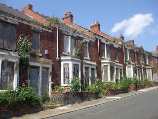 | ||
Where did benwell go part 1
Benwell is an area in the West End of Newcastle upon Tyne, England.
Contents
- Where did benwell go part 1
- Map of Benwell Newcastle upon Tyne UK
- Part 2 where did benwell go buddle road
- History
- Governance
- References
Map of Benwell, Newcastle upon Tyne, UK
Part 2 where did benwell go buddle road
History
Benwell village was recorded in A.D. 1050 known as Bynnewalle which roughly translates as "behind the wall" or "by the wall". Referring to its position relative to Hadrian's Wall (next to which was the Roman fort of Condercum, hence the nearby Condercum Road). At this time it was part of the Barony of Bolbec.
By the 13th century the medieval manor of Benwell had been subdivided, originally into two, but then one of the halves was further subdivided. So, although people usually refer to the three sections of Benwell Manor as ‘thirds’, this gives a misleading impression, because one of the ‘thirds’ was larger and wealthier than the other two. This third belonged to the Scot family, who were wealthy merchants from Newcastle and by 1296 they were the principal taxpayers in Benwell. The Scot family later went on to create a deer park in 1367, which later became Scotswood.
In the 16th century Benwell village was arranged in two rows of houses on either side of a wide street or green. A plain oblong tower, three storeys high with battlements around the roof was also recorded as being built.
In 1540, the crown (Henry VIII), took possession of Benwell Tower from Tynemouth Priory when it dissolved the monasteries.
Early in the 17th century, Benwell was split into smaller estates which were bought by the Shafto and Riddell families who were merchant families interested in exploiting the coal reserves on the banks of the Tyne.
Benwell Colliery was opened in 1766 and operated until 1938.
The original layout of Benwell exists in the form of Benwell Village, Benwell Lane, Ferguson's Lane and Fox and Hounds Lane however no buildings still exist other than from the early 19th century. The tower from the 16th century was rebuilt in the 18th century and then all traces were removed when the present hall, Benwell Towers was built in a Tudor style by John Dobson in 1831. Benwell Towers featured in the BBC television show Byker Grove.
By the 1990s, Benwell was widely regarded as one of the most troubled parts of Tyneside, if not the whole of Britain. In April 1994, The Independent reported that unemployment in the area stood at 24% (well over twice the national average) and that drug abuse and arson were both a major problem in the area, with a number of arson attacks known to have been carried out in an attempt to intimidate witnesses to crimes and deter them from giving evidence in court.
Governance
The area is represented on Newcastle City Council as part of the Benwell and Scotswood ward, with three Labour councillors, including Lord Jeremy Beecham,the former chairman of the Labour Party and the Local Government Association. He was first elected for Benwell in 1967.