
Status filled in Date of first use 1843 | Date closed 1960s Branch Neachells Lane Locks 10 | |
 | ||
Connects to | ||
The Bentley Canal is an abandoned canal that was part of the Birmingham Canal Navigations. A very short section still exists where it joins the Wyrley and Essington Canal in Wolverhampton. From there it headed generally southeast through Willenhall and Walsall and connected with the Anson Branch and thus the Walsall Canal. The main line opened in 1843, with the Neachell Hall Branch following two years later. The branch closed in 1953 and the main line in the early 1960s.
Contents
History
In 1820, the Birmingham Canal Company had approached the Wyrley and Essington Canal, with a view to amalgamation. This had been declined, but from 1825 mineowners in the Walsall area petitioned for a junction between the two systems. Nothing happened for some years, but in 1837, Walsall Town Council began pushing both companies for a solution. After much disagreement, the Wyrley and Essington announced that they were ready to apply for an Act of Parliament to authorise the construction of a junction at Walsall, which led to the Birmingham Canal Company agreeing to amalgamation. Both signed an agreement to proceed on 9 February 1840, and an Act of Parliament was obtained to April to authorise the move. The Bentley Canal was one of three links between the systems built shortly afterwards. The other two were the Walsall Junction Canal, which linked the north end of the Walsall Canal to Birchills Junction, and the Rushall Canal, between the Tame Valley Canal and the Daw End Branch of the Wyrley and Essington.
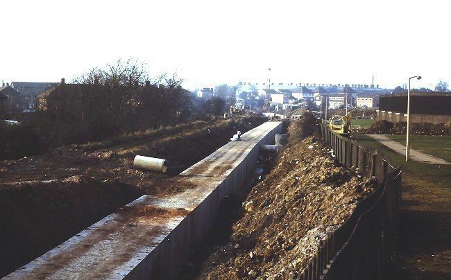
The canal was opened in 1843 and ran for 3.4 miles (5.5 km) through 10 locks. It fell into dereliction in the 1960s. The Neachells Branch was a 0.4-mile (0.64 km) branch which opened in 1845 to serve Neachell Hall Colliery and closed in 1953.
Route
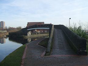
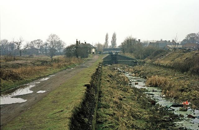
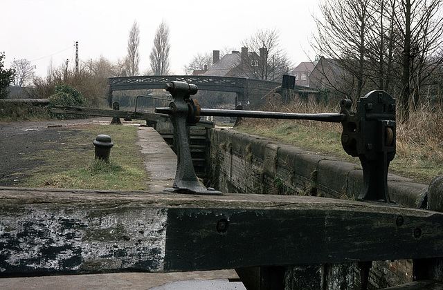
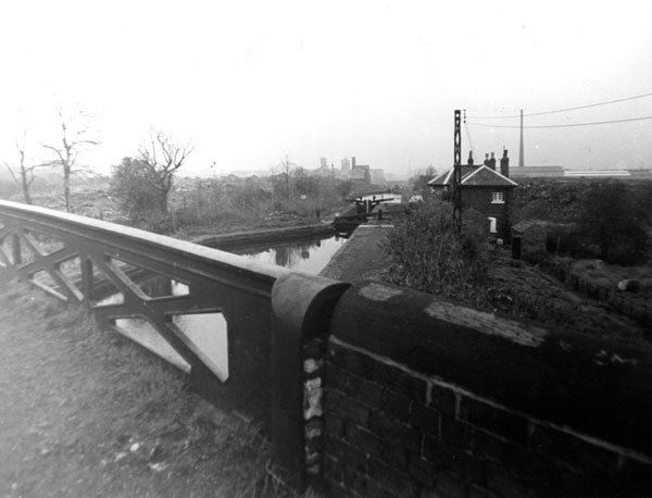
The Bentley Canal left the Wyrley and Essington Canal at Wednesfield Junction. A cast iron bridge carried the towpath over the junction, and is still in situ. It dates from the mid-nineteenth century, and is a grade II listed structure. A short section of the canal remains in water, and is used for moorings for the Nickelodeon canalside pub. The first lock was located immediately to the east of the watered stub, and was followed by two more. The canal is heading east at this point, and the towpath was located on the south bank. The remains of old quarries were on both sides of the canal, and there was a metal works washing plant on the north bank in the 1950s. Bradburn's Bridge carried a railway siding over the tail of the third lock. Beyond the bridge, Wolverhampton Metal Works occupied the south bank and there was a foundry on the north bank, although it had been a chocolate and confectionery works in 1902. The fourth lock was immediately before Well Lane Bridge. Between here and Neachells Bridge, there was a metal recovery works and allotment gardens on the north bank, and a cabinet works and two colour works to the south. This whole area has been redeveloped since the canal closed, although Well Lane and Neachells Lane still follow their original courses.
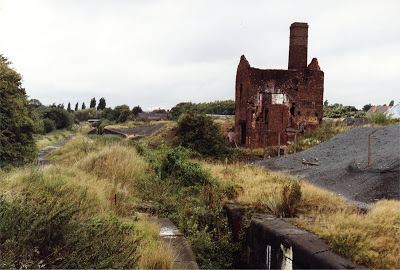
Two more locks occupied the next section, with Merrills Hall Bridge carrying Merrills Hall Lane over the canal just below the second. On the north bank were a steel works and a sports ground, which had been allotment gardens in 1938. A bowling green was nearest the canal, and a footbridge crossed it at this point. Reliance Works manufactured steel tubes on the south bank, and was sandwiched between the canal and a railway line. Beyond the bridge, Neachells Junction Bridge carried the towpath over the Neachells Branch. The branch headed due south. Another footbridge crossed it before it passed under a railway bridge. The settling tanks, filter beds and sludge beds of the Wednesfield Council sewage treatment works occupied the east bank of the branch beyond the bridge. A short arm to the east once served a coal mine, after which Water Lane crossed the canal. Beyond it, a wide basin served the Neachell Hall colliery, situated to the east of the canal, but disused by 1919.
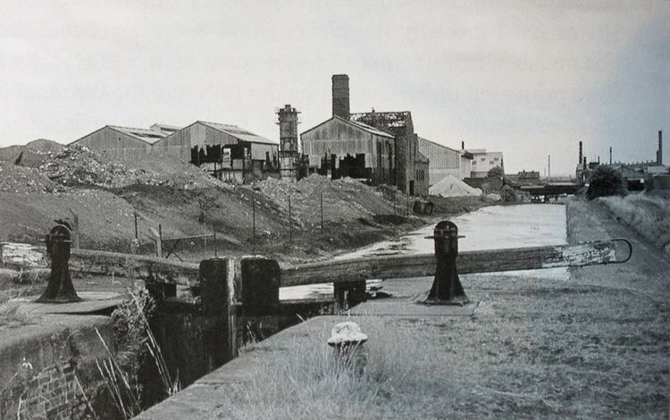
Returning to the main line, the Weldless Steel Tube Works were located on the north bank, and a gas furnace plant was to the south. Hill's Bridge carried a footpath over the canal. Fly Bridge, which was overshadowed by electricity pylons, carried another footpath. The Reliance Brass Foundry occupied the south bank just before Fibbersley Bridge, which now carries the B4484 road. Beyond it, the course of the canal is still clearly defined to the north of a housing estate. Dingle Bridge allowed walkers to cross from the end of Dingle Lane, while ar Monmer Lane, there were two bridges, one to carry the road and a separate footbridge immediately to the west. An industrial estate occupied the south bank, as the canal turned towards the south east. After Spring Bank Bridge, there was a wharf and a short arm, with a towpath bridge over it, which served the Spring Vale iron foundry, which later became the Spring Vale stamping works.
Next the canal passes between the remains of Short Heath Brick Works on the north bank and Spring Bank Brick Works on the south. There were two locks, with a small arm and wharf to the north, between them. Sandbeds Bridge connected Charles Street and Stringers Lane, beyond which a third lock was located beneath a railway bridge. The fourth lock on this section was just before Clarke's Lane Bridge, now carrying the A462 road. Farm Bridge joined the end of Durham Avenue. The canal turned to the south to pass under Wolverhampton Road West at County Bridge, and resumed its south-easterly course at Hopyard Bridge. A large cemetery occupies the north bank between the two bridges. Pendlebury Colliery occupied the south bank beyond the bridge, and had a small arm with a towpath bridge. The course of the canal is no longer visible from here, as its route is occupied by County Bridge Primary School. Beyond the school, Bentley Road North crossed at Bentley Lane Bridge, and the canal continued to join the Anson Branch just below Bentley Mill Bridge. The Anson Branch is no longer navigable, but is still partially watered.