
Highest elevation 20 m (70 ft) Elevation 5 m | Coastline .5 km (0.31 mi) Highest point unnamed point Area 5,000 m² | |
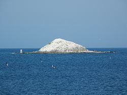 | ||
Benten-jima (弁天島) is a small deserted island west by northwest of Cape Sōya, Wakkanai, Hokkaidō, Japan. It is the northernmost piece of land under Japanese control. The island is 1 km north of Sannai settlement. Another island called Hira-shima (平島) lies southeast of Benten-jima.
Map of Benten-jima, Japan
Benten-jima is 0.005 square kilometres (0.0019 sq mi) in area, its perimeter is roughly 0.5 kilometres (0.31 mi), and its highest point is 20 metres (66 ft) above sea level. It is named after Benzaiten, once enshrined on the island. The wildlife includes many seabirds, Steller sea lions, kombu kelp, and sea urchins.
References
Benten-jima (Wakkanai) Wikipedia(Text) CC BY-SA