
Population 436 (2011 census) Elevation 1,400 m Local time Friday 7:18 AM | Postcode(s) 2365 Postal code 2365 | |
 | ||
Location 571 km (355 mi) N of Sydney402 km (250 mi) S of Brisbane62 km (39 mi) N of Armidale37 km (23 mi) S of Glen Innes Weather 13°C, Wind SW at 6 km/h, 97% Humidity | ||
Ben Lomond is a village on the Northern Tablelands in the New England region of New South Wales, Australia. The village is situated 6 km off the New England Highway between Armidale and Glen Innes. It was located in the Guyra Shire local government area until that council was amalgamated into the Armidale Regional Council on 12 May 2016, with parts of the surrounding district in Glen Innes Severn Shire and Inverell Shire. It is primarily a farming area, with most of the residents involved in sheep, cattle and grain farming.
Contents
Map of Ben Lomond NSW 2365, Australia
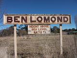
Ben Lomond Village is at 1,370 m elevation, making it the highest village in northern New South Wales. As such, even though it is located only a few hours' drive from the Queensland border, it receives occasional falls of snow in Winter. Overlooking the village are mountains known as "The Two Brothers", which have a peak elevation of 1,508 metres.
History
The name Ben Lomond originated from Ben Lomond in Scotland.
In 1848, the Manooan run of 17,000 acres (69 km2) had the Ben Lomond Range as its southern boundary. In the 1860s there was a station named Ben Lomond which had been robbed by Captain Thunderbolt, who frequented the region. The slow climb and timber on the Ben Lomond Range proved an ideal place for the robbery of coaches and travellers.
The Dumaresq to Glen Innes section of the Main North railway Line, which included Ben Lomond, opened on 19 August 1884. At 1,363 metres (4,472 ft), Ben Lomond railway station was the highest railway station in New South Wales until the Skitube opened in 1987. Ben Lomond railway station closed on 10 December 1985, followed by the Dumaresq-Glen Innes section on 3 October 1993.
Ben Lomond Post Office opened on 4 November 1879 and closed in 1979. Ben Lomond was serviced by a general store providing the majority of day-to-day needs as well as farming supplies until it closed in November 2007.
Population
At the 2011 census, the Census area containing Ben Lomond village and district had a recorded population of 436. Of these people:
The census area called "Ben Lomond" covers a considerable area (816 square km), especially to the east of Ben Lomond township, including the small settlements of Llangothlin, Tibbamurra, Falconer, Bald Blair and Green Hills. As a result, many of the people who are included in this census area may not normally classify themselves as living in Ben Lomond. Unpublished analysis by one resident who was working on the town plan estimated that about 30 persons in the village, and approximately a further 70 persons in the immediate area of mostly farming families, would identify themselves as "living in the Ben Lomond area".
Features
Ben Lomond Public School, located on Inn Road, has been reduced in recent years from thirty students in the mid nineties to a current enrolment of around twelve students. The lack of jobs in the immediate area, drought, as well as the proximity to Glen Innes and Guyra has been a factor in this change in school size.
Ben Lomond has three Churches representing the Anglican, Presbyterian and Roman Catholic denominations.
Ben Lomond is home to several tourist attractions, including home stays, the longest hand cut railway cutting in Australia, the highest passenger railway station in the southern hemisphere (at the time of the construction of the railway), and a scattering of old and historical relics of past times in and around the village. Other amenities include a community hall and a volunteer brigade of the Rural Fire Service.
The highland areas that include the Ben Lomond district are the focus areas for possible development of large scale wind farms. The original proposal was by Allco, which ran into severe financial problems and eventually liquidated on 4 November 2008, so that project was abandoned.
Ben Lomond community has traditionally been active through several groups and local initiatives to maintain and progress the village and district. In recent years the village has formed something of a local rivalry with neighbouring Glen Innes in the form of an annual inter-town friendly cricket match. Whilst at a substantial size disadvantage, Ben Lomond have won four of the games so far, and drawn the other. Games are played on the Ben Lomond Recreational Ground, which once played host to regular games but is seldom used outside of the fixture.