
OS grid reference SK819334 Post town GRANTHAM Local time Thursday 6:59 PM Dialling code 01476 | Sovereign state United Kingdom | |
 | ||
Weather 5°C, Wind SW at 13 km/h, 61% Humidity | ||
Belvoir /ˈbiːvər/ BEE-vər is a village and civil parish in the Melton district of Leicestershire, England. It is close to the county boundary with Lincolnshire, the nearest town being Grantham, 8 miles (13 km) east of the village.
Map of Belvoir, UK
The parish includes the villages of Belvoir, Knipton and Harston. Nearby places outside the parish are Woolsthorpe by Belvoir, Redmile, and Croxton Kerrial.
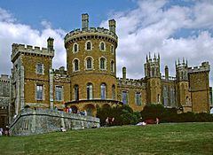
The village is the site of Belvoir Castle, which "stands on a prominent spur jutting northwards" into the Vale of Belvoir.
References
Belvoir, Leicestershire Wikipedia(Text) CC BY-SA