Suvarna Garge (Editor)

BeltLine

Updated on
Edit
Like
Comment
Share on FacebookTweet on TwitterShare on LinkedInShare on Reddit
Legal status
  
Georgia Non-Profit

Website
  
beltline.org

Location
  
Atlanta, Georgia

Founded
  
April 2005

BeltLine Adopt the Atlanta BeltLine

Formation
  
April 2005 (12 years ago)

Purpose
  
Urban redevelopment and mobility

President and Chief Executive Officer (ABI,) Executive Director (ABP)
  
Paul Morris (ABI) Rob Brawner (ABP)

Motto
  
Where Atlanta Comes Together

Main organ
  
Atlanta BeltLine Partnership

Profiles

Mud creek near the brick works along the beltline trail


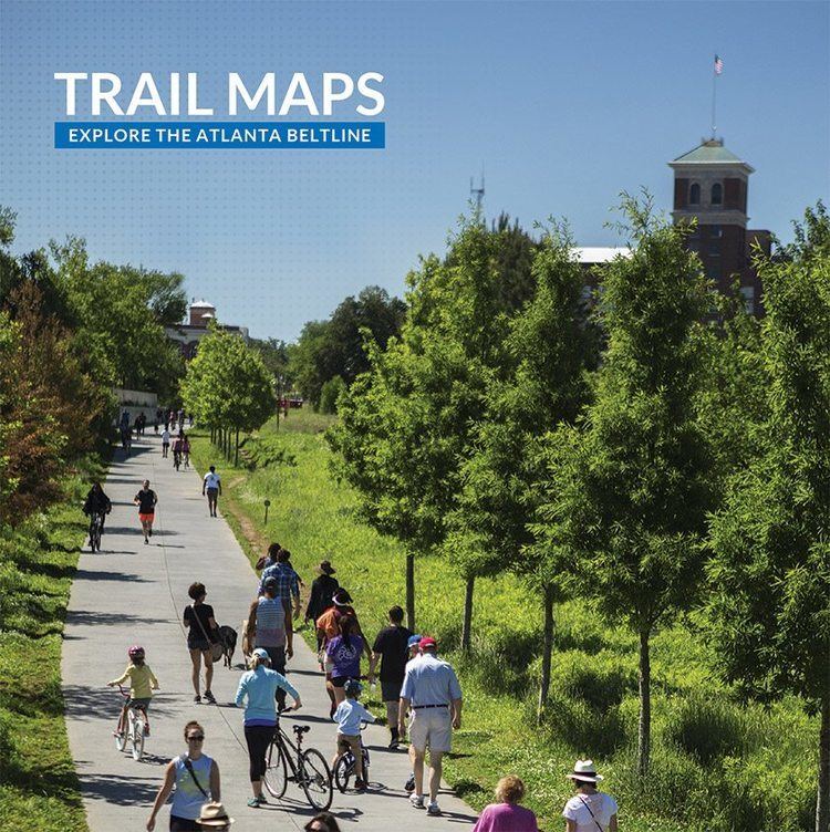
The BeltLine (also Beltline or Belt Line) is a former railway corridor around the core of Atlanta, Georgia, under development in stages as a multi-use trail. Some portions are already complete, while others are still in a rough state but hikeable. Using existing rail track easements, the BeltLine is designed to improve transportation, add green space, and promote redevelopment. There are longer-term visions for streetcar or light-rail lines along all or part of the corridor.

Contents

BeltLine Eastside Trail

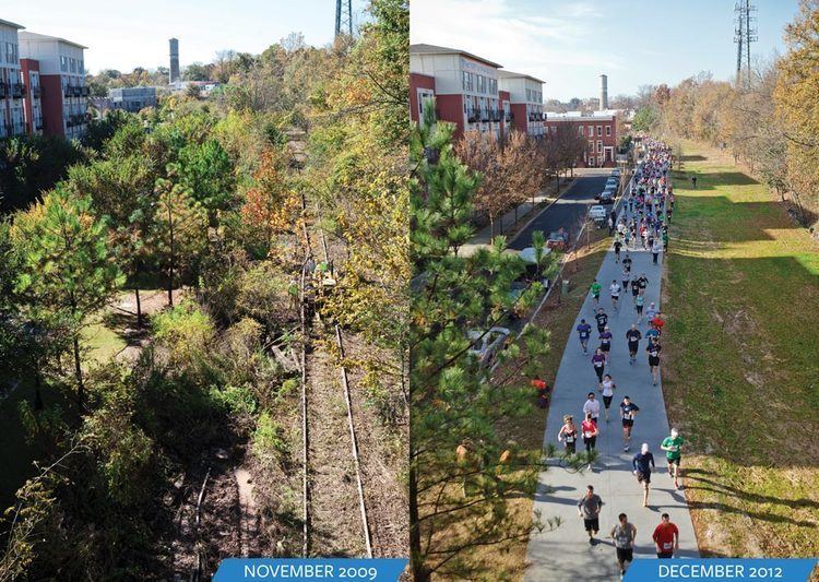
The BeltLine plan was originally developed in 1999 as a masters thesis by Georgia Tech student Ryan Gravel. It links city parks and neighborhoods, but has also been used for temporary art installations. In 2013, the project received a federal grant of $18 million to develop the southwest corridor.

BeltLine Walking 19 Miles of the Atlanta BeltLine The City Dweller

Rail removal for atlanta s beltline


Concept

BeltLine Invest Atlanta Atlanta BeltLine TAD

The idea originated in a 1999 master's degree thesis by Georgia Tech student Ryan Gravel, who founded the non-profit Friends of the Belt Line and works for Perkins+Will. Frustrated with the lack of transportation alternatives in Atlanta, Gravel and two of his colleagues, Mark Arnold and Sarah Edgens, summarized his thesis in 2000 and mailed copies to two dozen influential Atlantans. Cathy Woolard, then the city council representative for district six, was an early supporter of the concept. Woolard, Gravel, Arnold, and Edgens spent the next several months promoting the idea of the BeltLine to neighborhood groups, the PATH foundation, and Atlanta business leaders. Supported by Atlanta mayor Shirley Franklin, previous city council president Cathy Woolard, and many others in Atlanta's large business community, the idea grew rapidly during 2003 and 2004.

BeltLine Atlanta BeltLine Where Atlanta Comes Together

The railroad tracks and rights-of-way are owned mostly by CSX Transportation, Norfolk Southern, and the Georgia Department of Transportation. Developer Wayne Mason had purchased most of the NS portion, in anticipation of the BeltLine, but later sold it after conflict with the city.

BeltLine Beltline Corridor Design

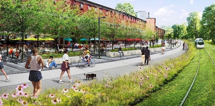
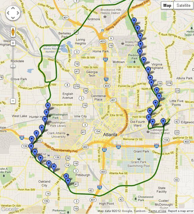
The total length will be 22 miles (35 km), running about 3 miles (5 km) on either side of Atlanta's elongated central business district. It is planned to include a neighborhood-serving transit system (likely streetcars); footpaths for non-motorized traffic, including bicycling, rollerskating, and walking; and the redevelopment of some 2,544 acres (1,030 ha). The project (although not the funding for it) is included in the 25-year Mobility 2030 plan of the Atlanta Regional Commission for improving transit. As of 2014, the project's planners estimated they had 17 years left before the project would be completed, and no light-rail lines had yet been built.
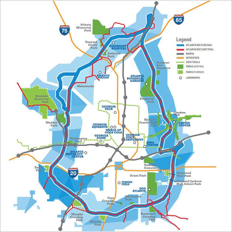
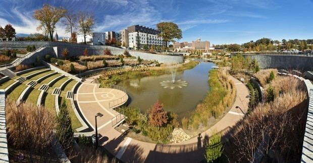
Park component

BeltLine The Beltline Impact

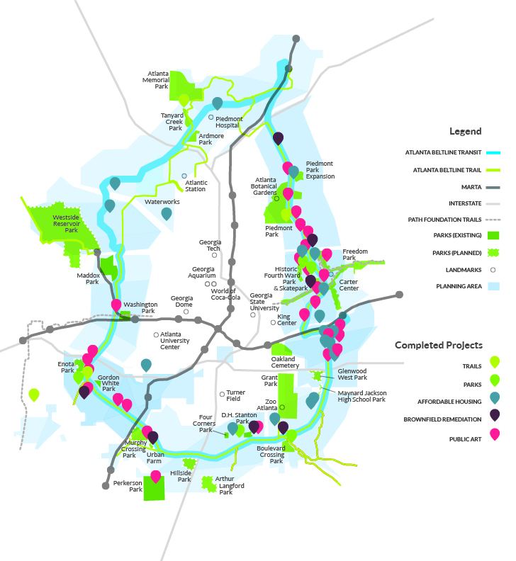
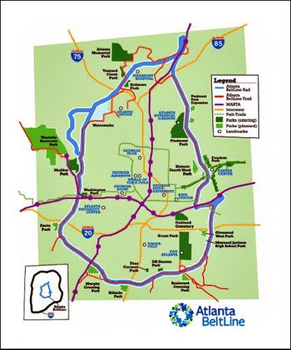
The BeltLine plan calls for the creation of a series of parks throughout the city creating what the working plan, The Beltline Emerald Necklace, calls the thirteen "Beltline Jewels"; they would be connected by the trail and transit components of the plan. In total, the BeltLine will create or rejuvenate 1,300 acres (530 ha) of greenspace. The Trust for Public Land first identified areas that would be appropriate for parkland, and spurred the inclusion of the park component in the current plan. The Trust is active in acquiring land for the project, which it intends to sell to the city after bonds have been issued from the beltline tax-allocation district.

The plan would expand these existing parks:

BeltLine Can Atlanta Go All In on the BeltLine CityLab

  • Enota Park from 0.3 to 10 acres (0.12 to 4.05 ha)
  • Maddox Park from 52 to 114 acres (21 to 46 ha)
  • Ardmore Park 2 to 8 acres (0.81 to 3.24 ha)
  • It would also create these new parks:

    BeltLine beltlineorgwpenginenetdnacdncomwpcontentthe

  • Peachtree Creek Park 65 acres (26 ha) at Peachtree Creek near Buckhead
  • Hillside Park 28 acres (11 ha) at the current McDaniel CEO facility
  • Holtzclaw Park 2 acres (0.81 ha)
  • Historic Fourth Ward Park (63 acres (25 ha) at the to-be-renovated Ponce City Market (formerly the Sears building and City Hall East)
  • Waterworks Park 204 acres (83 ha)
  • Westside Park 351 acres (142 ha) – roughly twice the size of Piedmont Park – on the site of the former Bellwood Quarry. The 100-foot-deep (30 m) former gravel pit will become a reservoir.
  • Multi-use trails

    BeltLine With the Beltline Atlanta Wants to Become a New City The Dirt

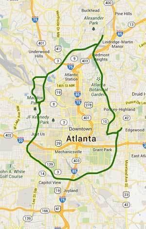
    The BeltLine will feature a continuous path encircling the central part of the city, generally following the old railroad right of way, but departing from it in several areas along the northwest portion of the route. In total, 33 miles (53 km) of multi-use paths are to be built, including spur trails connecting to neighborhoods. The PATH Foundation, which has many years of experience building such trails in the Atlanta area, is a partner in the development of this portion of the system.
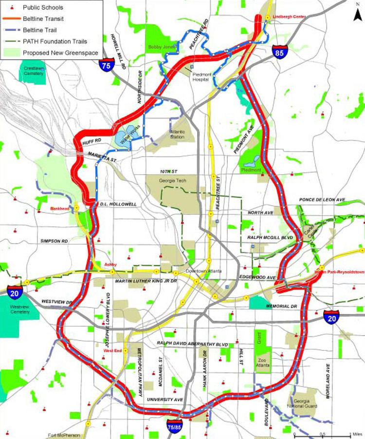
    Transit elements

    BeltLine The Atlanta BeltLine The country39s most ambitious smart growth

    The original focus of the BeltLine thesis was on establishing a 22-mile (35 km) light rail loop around the central portion of the city. The vision has expanded to include trails, parks and greenspace, streetscapes, public art, affordable housing, economic development, environmental sustainability, and historic preservation. In Summer 2012, there was a referendum on whether a 1-cent sales tax (SPLOST) should be implemented to fund traffic and road improvements. If approved, the tax would have funded several streetcar routes along portions of the BeltLine trail and connections to MARTA stations and the Downtown Loop streetcar. The sales tax did not pass.

    In 2013, Atlanta BeltLine, Inc. (ABI) entered into a services agreement with the City of Atlanta to advance key transportation projects that support the BeltLine’s success. The first order of business was the Atlanta Streetcar Extension environmental review, and federal environment reviews are now underway for Atlanta BeltLine East, Atlanta BeltLine West, and the Crosstown-Midtown Streetcar, in addition to the Atlanta Streetcar Downtown Extension.

    Art

    "Art on the Atlanta BeltLine" is the city of Atlanta's largest temporary public art exhibition that showcases the work of hundreds of visual artists, performers, and musicians along nine miles (14 km) of the BeltLine corridor. The first exhibition was in 2010.

    Usage issues

    While the Metropolitan Atlanta Rapid Transit Authority (which runs the MARTA system) is excited about the surface-level addition to its existing above-ground and subway system, GDOT has reservations, as the lines it previously purchased were intended for use as commuter rail connections. CSX also is concerned, as passenger trains would have to pass through a major regional railyard, intermingling with freight trains and possibly causing issues of delays and potential legal liability.

    In late January 2009, GDOT and Amtrak made an unannounced and last-minute filing with the Surface Transportation Board that would effectively block the northeast part of the BeltLine, instead taking it for future intercity rail. However, this conflict was later resolved.

    Discontinuities

    There are five gaps along the BeltLine where rights of way do not connect and thus create larger challenges to the project.

    1. Armour — Near the Lindbergh Center MARTA station, bisected by two active rail lines. Solving this would involve transit sharing the rail right-of-way and splitting off the trail where Clear Creek joins Peachtree Creek, following Clear Creek around the Armour warehouse properties then tunneling under the active rail lines and I-85 to the Ansley Golf Course then rejoining the BeltLine.
    2. CSX Hulsey Yard — Near the Inman Park/Reynoldstown MARTA station. A workaround for the trail is to utilize the existing tunnel at Krog Street.
    3. Bill Kennedy Way (also known variously as the Glenwood-Memorial Connector and the Glenwood-Wylie Connector) — a bridge spanning I-20 between Glenwood Park/Ormewood Park and Reynoldstown. The proposed fix here is to widen the bridge enough to support trail, transit and motor traffic.
    4. Washington Park to Simpson Rd — near the Ashby MARTA station. Proposals include a span over the MARTA tracks or possibly share the right of way.
    5. Bankhead — The largest gap is near Maddox Park and involves one of the busiest rail corridors in the state. Proposals include 1) taking the trail east to cross under Hollowell Pkwy; 2) diverting through Mead property at Marietta Blvd; or 3) sharing the road with Lowery (formerly Ashby Street).

    History

    The first development of the BeltLine area began when the Atlanta & West Point Railroad began building a 5-mile (8 km) connecting rail line from its northern terminus at Oakland City to Hulsey Yard on the Georgia Railroad (essentially the southeast quarter of the completed BeltLine). The surveys were done and initial construction had begun when the courts ordered a halt in May 1899 as that work did not fall under the A&WP's charter.

    In September 1899, a more ambitious charter for an Atlanta Belt Railway Company was announced that would circle the entire city connecting all rail lines so that freight car transfers could occur on the outskirts rather than downtown. The initial charter was to encompass no more than 30 miles (48 km) and named only perimeter points Howell and Clifton Stations. Since Clifton was in DeKalb County, both it and Fulton were named in the charter. After surveys of the route and right of way acquisitions, the DeKalb portion was ditched leaving the entire route in Fulton County. The entire line was completed by 1902.

    Timeline

  • 1999 Ryan Gravel's master's thesis
  • 2003 Georgia Tech senior design project is first feasibility study done on the beltline and presented to the Atlanta City Council. The study included the first public support analysis which showed overwhelming public support for the project.
  • 2004 Trust for Public Land publishes Alexander Garvin's Emerald Necklace proposal
  • 2005
  • July — Atlanta BeltLine Partnership formed
  • November 7 — city council approves Tax-allocation district and Redevelopment Area (14-3)
  • December 12 — Atlanta school board unanimously approves TAD
  • December 21 — Fulton County Commission approves TAD(5-1)
  • 2006
  • April 19 — Fulton County Commission approves (5-2) sale of Bellwood Quarry for Westside Park.
  • July — Atlanta BeltLine, Inc. (ABI) was formed by Invest Atlanta and the Five Year Work Plan was adopted by City Council.
  • September 21 — developer Wayne Mason who owns the 5-mile (8 km) northeast segment (from DeKalb Ave up through Ansley Park) withdraws his rezoning applications from the city. Mason, a suburban land speculator, had purchased the railroad right of way from Norfolk Southern in 2004. Rather than preserving the property as a greenway and transit corridor, Mason proposed a deal with the city whereby he would give a portion of his land in exchange for the right to develop the remainder to extremely high densities. The most controversial component of his plan was a proposal to build 38- and 39-story condominiums on the eastern edge of Piedmont Park, in an area dominated by historic single family homes. Mason's proposal galvanized the adjacent neighborhoods to organize, forming the Beltline Neighbors Coalition. Despite paid lobbying on Mason's behalf by such heavyweights as former Governor Roy Barnes, in the end the city held firm with the original intention of preserving the corridor as transit and greenspace.
  • December 11 — After soliciting comments from the public, MARTA recommends rail service (including either modern streetcar or light rail technology) for the corridor, even though bus rapid transit technology would have possible lower capital costs.
  • 2007
  • January — The Atlanta BeltLine Affordable Housing Advisory Board (BAHAB) was established.
  • March — The Atlanta BeltLine Tax Allocation District Advisory Committee (TADAC) was established.
  • March — Master planning and community engagement commenced, consistent with the Citizen Participation Framework adopted by City Council.
  • June 13 — city of Atlanta purchases over 21 acres (8.5 ha) near Grant Park for part of the "jewel" called Boulevard Crossing in the Emerald Necklace study.
  • August 7 — Atlanta Beltline Inc acquires the first section of the corridor. In partnership with Ben Raney and Barry Real Estate Companies, ABI announces the purchases of the NE section of the Atlanta BeltLine from developers Wayne and Keith Mason.
  • November 12 — $8 million allocated to purchase land where North Avenue crosses the Beltline for a 16-acre (6.5 ha) park (which can later be expanded to 35 acres (14 ha)).
  • 2008
  • February 23 — 150 people attended a community groundbreaking for the West End (Atlanta) trail at Rose Circle Park.
  • Summer — MARTA and the Federal Transit Administration, in partnership with ABI, commenced the Tier 1 Environmental Impact Statement, to make the project competitive for future federal transit funding.
  • October 15 — Groundbreaking takes place for the Historic Fourth Ward Park on North Avenue, the first part of the BeltLine.
  • October — West End Trail Phase I (1.5 miles or 2.4 km), built by the PATH Foundation, opened in southwest Atlanta — enhanced by Trees Atlanta’s Atlanta BeltLine arboretum. Atlanta BeltLine renovated Gordon White Park.
  • October — Atlanta BeltLine Affordable Housing Trust Fund policies adopted by City Council. First Atlanta BeltLine TAD Bonds issued, totaling $64.5 million. The Atlanta BeltLine Affordable Housing Trust Fund was capitalized with $8.8 million in TAD Bond proceeds.
  • 2009
  • June — With the Atlanta BeltLine TAD Advisory Committee, ABI developed and adopted an equitable development plan.
  • July — ABI entered an option agreement and a lease with GDOT for 3.5 miles (5.6 km) of the Atlanta BeltLine corridor in the southwest and Reynoldstown.
  • December — Groundbreaking on the first trail occurs, where mayor-elect Kasim Reed announces he wants to make the BeltLine a reality in 10 years, instead of 25.
  • 2010
  • April — Opening ceremony for a 1-mile (1.6 km) segment of trail that snakes through Tanyard Creek Park, Louise G. Howard Park, and along Bobby Jones Golf Course.
  • May — Art on the Atlanta BeltLine, first ever temporary public art exhibit on the Atlanta BeltLine, opened to the public. The Atlanta BeltLine Lantern Parade was born.
  • June 19 — $5 million donation from Kaiser Permanente and PATH to build graded hardscape from DeKalb Ave north to Ponce de Leon Ave to be completed within a year.
  • July — The West End Trail Phase II (1 mile) in southwest Atlanta, built by the PATH Foundation, opened to the public for a total of 2.5 miles (4.0 km).
  • October — ABI adopted Community Benefit Guiding Principles.
  • 2011
  • May — D.H. Stanton Park re-opened to the public as an eight-acre (3.2 ha) park on the Atlanta BeltLine corridor in southeast Atlanta.
  • June — Historic Fourth Ward Park and Skatepark (17 acres or 6.9 ha total) opened to the public.
  • September — Boulevard Crossing Park Phase I (5 acres or 2.0 ha) opened to the public.
  • September — Second annual Art on the Atlanta BeltLine exhibit is held.
  • September — ABI acquired former Triumph Lofts development out of receivership to convert to affordable housing as the Lofts at Reynoldstown Crossing in southeast Atlanta.
  • December — ABI held first-ever drawing for 28 new affordable homes at the Lofts at Reynoldstown Crossing.
  • 2012
  • April — The final of 10 Master Plans for the Atlanta BeltLine planning area was adopted by Atlanta City Council, completing the 5-year citywide effort.
  • May — ABI and City of Atlanta Department of Parks, Recreation and Cultural Affairs opened the new splash pad in Perkerson Park in southwest Atlanta.
  • August — ABI Board of Directors adopted the Atlanta BeltLine Environmental Justice Policy.
  • September — The Federal Transit Administration issued a Record of Decision for the Tier 1 Environmental Impact Statement — a critical step towards securing federal transit funding.
  • August — The then current CEO Brian Leary was forced to resign over amid controversy about the organization's reported use of taxpayer dollars to fund non-business expenses.
  • October 15 — The Eastside Trail opened to the public — the first section of trail to be built within the old railroad corridor.
  • 2013
  • January — Groundbreaking ceremony for phase I of the Southwest Connector Trail.
  • March — Walking tours of the Atlanta BeltLine Arboretum launched, spearheaded by Trees Atlanta.
  • May — A new path was dedicated in Lang Carson Park in Reynoldstown.
  • June — CEO Paul Morris started with Atlanta BeltLine, Inc.
  • July — The dedicated Path Force police officers started patrolling all Atlanta BeltLine parks and trails.
  • August — Phase I of the Southwest Connector Trail officially opened.
  • August — Atlanta BeltLine, Inc. (ABI) entered into a services agreement with the City of Atlanta to advance key transportation projects that support the Atlanta BeltLine’s success.
  • September — The Atlanta BeltLine received a federal TIGER V grant of $18 million to develop the southwest corridor of the Atlanta BeltLine. The future Westside Trail will be a 2.5-mile (4.0 km) multi-use trail from Washington Park to University Avenue with 16 access points.
  • September — The Atlanta BeltLine Lantern Parade attracted over 10,000 people to light up the night along the Eastside Trail.
  • November — The Atlanta BeltLine Partnership launched free fitness classes along the Atlanta BeltLine.
  • November — Atlanta BeltLine Bike Tours began.
  • November — The Atlanta BeltLine online shop officially opened.
  • 2014
  • August 22 — Eastside Trail Gateway is opened by mayor Kasim Reed. It connects Historic Fourth Ward Park to the BeltLine at 33.7690541°N 84.3636233°W / 33.7690541; -84.3636233.
  • Forthcoming

  • GDOT approval of the following BeltLine multi-use path projects (See p. 99)
  • AR-450A $20 million (35% federal dollars) 2007 (includes $17 million for ROW)
  • AR-450B Bicycle/pedestrian 2008 $19 million (58% federal)
  • AR-450B Bicycle/pedestrian 2020 $15 million (100% city of Atlanta)
  • References

    BeltLine Wikipedia