
 | ||
Belle Isle (French for 'Beautiful Island') is an uninhabited island just off the coast of Labrador and north of Newfoundland at the Atlantic entrance to the Strait of Belle Isle which takes its name. Named by French explorer Jacques Cartier, the island lies on the shortest shipping lane between the Great Lakes and Europe, and also on the main north–south shipping route to Hudson Bay and the Northwest Territories. The northern terminus of the International Appalachian Trail is located on Belle Isle.
Map of Belle Isle, Division No. 9, Subd. D, NL, Canada
Belle Isle rises to about 213 m (699 ft) at its highest point, 52 km2 (20 sq mi) in area, 16 km (9.9 mi) long and 5 km (3 mi) wide. It is nearly 24 km (15 mi) from either coast, though slightly closer to the Labrador side of the Strait of Belle Isle, and has a lighthouse (supported by flying buttresses) at both its northern and southern ends. Officially uninhabited, there is some seasonal occupation during fishing season.
Belle Isle is the northernmost peak of the Appalachian Mountains, which extend in various shapes over 3,200 km (2,000 mi) southwest to Alabama, US.
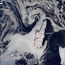
Ice patterns show that the island lies at the meeting point of two sea currents: The Labrador Current flows from the northwest, and a smaller current, driven by dominant westerly winds, flows from the southwest. Flow lines in sea ice give a sense of the movement of the ice. Ice floes embedded in the Labrador Current appear as a relatively open pattern. Sea ice with a denser pattern enters from the strait, banking against the west side of Belle Isle. Tendrils flow around capes at either end of the island, with an ice-free "shadow" on the opposite, downstream side. Eddies off the western coast in the ice patterns (indicated by curved arrows in the photo) show where the currents interact north and west of the island.