Girish Mahajan (Editor)

Belihuloya

Updated on
Edit
Like
Comment
Share on FacebookTweet on TwitterShare on LinkedInShare on Reddit
Country
  
Province
  
Sabaragamuwa Province

Belihuloya secbstaticcomimageshotelmax40021521584286jpg

Time zone
  
Sri Lanka Standard Time Zone (UTC+5:30)

Belihuloya holiday homes belihuloya sri lanka


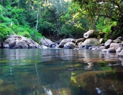
Belihuloya is a village in the Ratnapura District, Sabaragamuwa Province of Sri Lanka. It is approximately 150 kilometres (93 mi) south-east of Colombo and is situated at an elevation of 616 metres (2,021 ft) above sea level. This hillside location is a climatically transitional area, linking both the dry and wet zones and the hill and low country. Belihuloya, is derived from the Belih Oya ("Oya" being the Sinhala word for river), which flows through the area.

Contents

Map of Belihuloya, Sri Lanka

River garden resort belihuloya sri lanka


Transport

It is located on the B339 (Olugantota-Pinnawala-Bogawantalawa Road).

Natural attractions

The area around Belihuloya contains a number of waterfalls, including:

  • Pahanthuda Ella (also known as Galagama Ella) - The base of this 4.6 metres (15 ft) waterfall is shaped like an oil lamp. The name Pahanthuda is derived from the Sinhala word “pahana” for lamp. It is located approximately 1.5 kilometres (0.93 mi) from Belihuloya.
  • Bambarakanda Ella (also known as Bambarakele Ella) - The highest waterfall in Sri Lanka, it is 263 m (863 ft) in height and ranks as the 299th highest waterfall in the world. It is located approximately 18 kilometres (11 mi) from Belihuloya.
  • Surathalee Ella - It is not actually a waterfall but a water-slip. The water, slides down along a rock wall on the eastern slope of Mt Ellamana for approximately 20 metres (66 ft), forming this water-slip. It is located 8 kilometres (5.0 mi) from Belihuloya.
  • Brampton Falls - The tributary of Weli Oya flows down the eastern slopes of Mt Papulagala (1530m) forming several cascades among the trees of the surrounding monsoon forest. This fall is approximately 6 metres (20 ft) in height and is located amongst several other smaller falls. It is located about 10 kilometres (6.2 mi) from Belihuloya.
  • Papulagala Ella - Located in the Brampton Estate (Tea Plantation) on the slopes of Mt. Papulagala. During the rains a brook forms this waterfall, which is about 30 metres (98 ft) high. It is located 5 kilometres (3.1 mi) east of Belihuoya at Lower Hiralouvah
  • Physical attractions

  • Samanala Dam is the second-largest hydroelectric scheme in Sri Lanka, generating 405 GWh of energy annually. The dam is located 9.4 kilometres (5.8 mi) south of Belihuloya.
  • Education

    The Sabaragamuwa University of Sri Lanka (SUSL) is located 500m from the Pambahinna Junction, on the A4 highway which runs through Belihuloya. Administratively, SUSL belongs to the Imbulpe Divisional Secretariat and to the Rathnapura District in Sabaragamuwa Province.

    References

    Belihuloya Wikipedia