
Country United States FIPS code 55-06175 Elevation 225 m Population 2,245 (2010) Area code 262 | State Wisconsin Time zone Central (CST) (UTC-6) GNIS feature ID 1582782 Area 6.27 km² Local time Thursday 12:59 AM | |
 | ||
Weather -7°C, Wind NW at 11 km/h, 80% Humidity | ||
Wester electric belgium wisconsin
Belgium is a village located in the Town of Belgium in Ozaukee County, Wisconsin, United States. The population was 2,245 at the 2010 census.
Contents
- Wester electric belgium wisconsin
- Map of Belgium WI USA
- History
- Geography
- 2010 census
- 2000 census
- Notable people
- Education
- References
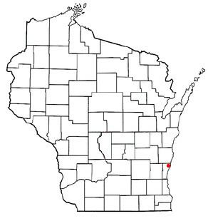
Map of Belgium, WI, USA
History
The first settlement at Belgium was made in 1848. A large share of the early settlers being natives of Belgium caused the name to be selected. A post office called Belgium has been in operation since 1857.
Geography
Belgium is located at 43°30′2″N 87°50′48″W (43.500735, -87.846897).
According to the United States Census Bureau, the village has a total area of 2.42 square miles (6.27 km2), all of it land.
Belgium is two miles (3 km) west of Lake Michigan, adjacent to conjoined Interstate 43-State Highway 32.
2010 census
As of the census of 2010, there were 2,245 people, 817 households, and 608 families residing in the village. The population density was 927.7 inhabitants per square mile (358.2/km2). There were 848 housing units at an average density of 350.4 per square mile (135.3/km2). The racial makeup of the village was 94.5% White, 0.4% African American, 0.4% Native American, 0.9% Asian, 2.9% from other races, and 0.8% from two or more races. Hispanic or Latino of any race were 5.2% of the population.
There were 817 households of which 41.9% had children under the age of 18 living with them, 66.0% were married couples living together, 5.1% had a female householder with no husband present, 3.3% had a male householder with no wife present, and 25.6% were non-families. 20.7% of all households were made up of individuals and 6% had someone living alone who was 65 years of age or older. The average household size was 2.74 and the average family size was 3.24.
The median age in the village was 35 years. 29.7% of residents were under the age of 18; 4.6% were between the ages of 18 and 24; 33.8% were from 25 to 44; 23.5% were from 45 to 64; and 8.3% were 65 years of age or older. The gender makeup of the village was 51.0% male and 49.0% female.
2000 census
As of the census of 2000, there were 1,678 people, 582 households, and 444 families residing in the village. The population density was 1,163.0 people per square mile (449.9/km²). There were 592 housing units at an average density of 410.3 per square mile (158.7/km²). The racial makeup of the village was 96.31% White, 0.48% Black or African American, 0.42% Native American, 0.18% Asian, 1.49% from other races, and 1.13% from two or more races. 4.11% of the population were Hispanic or Latino of any race. There were 1582 households out of which 44.5% had children under the age of 18 living with them, 67.9% were married couples living together, 5.8% had a female householder with no husband present, and 23.7% were non-families. 19.6% of all households were made up of individuals and 7.4% had someone living alone who was 65 years of age or older. The average household size was 2.85 and the average family size was 3.31.
In the village, the population was spread out with 31.8% under the age of 18, 6.8% from 18 to 24, 36.1% from 25 to 44, 16.5% from 45 to 64, and 8.8% who were 65 years of age or older. The median age was 32 years. For every 100 females there were 101.2 males. For every 100 females age 18 and over, there were 99.5 males.
The median income for a household in the village was $53,523, and the median income for a family was $59,375. Males had a median income of $40,152 versus $25,609 for females. The per capita income for the village was $20,659. About 1.8% of families and 2.4% of the population were below the poverty line, including 2.8% of those under age 18 and 6.0% of those age 65 or over.
Notable people
Education
The village shares the Cedar Grove-Belgium School District with Cedar Grove. The Cedar Grove-Belgium High School is the local high school.