
Main source Iremel mountain Basin area 142,000 km² Mouth Kamadeva Bridges Ufa Rail Bridge | Length 1,430 km Source Iremel Country Russia | |
 | ||
River mouth Kama, Nizhnekamsk Reservoir Basin size 142,000 km (55,000 sq mi) Discharge Average rate:
858 m/s (30,300 cu ft/s) (near Birsk) | ||
Belaya River (Russian: Бе́лая, Belaja; Bashkir: Ағиҙел, Ağiźel [ä.ʁi̠.ˈðɪ̞l], pronunciation ; Tatar: Агыйдел, Ağídel, اعىدئل [ˌʌɣiˈdel]) is a river in Bashkortostan, Russian Federation. Its source lies in the south-western Ural Mountains.
Map of Belaya River, Russia
It is 1,430 kilometres (890 mi) long.
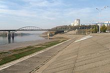
Settlements along the Belaya include Beloretsk, Sterlitamak, Ufa (at the confluence with the Ufa River), and Birsk. The Belaya flows into the Kama River near Neftekamsk.
References
Belaya River (Kama) Wikipedia(Text) CC BY-SA