
Population (2015) 1,631 | Founded 1949 Local time Thursday 3:36 AM | |
 | ||
Weather 12°C, Wind W at 14 km/h, 90% Humidity | ||
Mark eliyahu ballad for the weeping spring
Beit Zayit (Hebrew: בֵּית זַיִת, lit. House of Olives) is a moshav in Israel. Located just outside the Jerusalem municipal border to the west, it falls under the jurisdiction of Mateh Yehuda Regional Council. In 2015 it had a population of 1,631.
Contents
- Mark eliyahu ballad for the weeping spring
- Map of Beit Zayit Israel
- Yeshiva bochur drowns in beit zayit
- History
- Dinosaur Footprints
- References
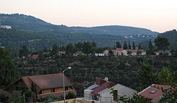
Map of Beit Zayit, Israel
Beit Zayit lies on the edge of the Jerusalem Forest and operates a public swimming pool. Nearby is the Ein Kerem dam, built to store winter flood waters.
Yeshiva bochur drowns in beit zayit
History
A village named Beit Zayit is mentioned in the book of the Maccabees, but it is believed to have been further north, possibly at the site of the Palestinian Christian town of Bir Zeit, north of Ramallah.
The modern village was established in 1949 by Jewish immigrants from Yugoslavia, Romania, and Hungary. Later immigrants from Yemen and Egypt also settled in the village. The economy was based on fruit orchards, vegetables, poultry, and other farm products.
With the expansion of the moshav in the late 1990s, including the purchase of land by newcomers and renovation of old homes, Beit Zayit became a trendy alternative to living in Jerusalem.
Dinosaur Footprints
In 1962 Dinosaur footprints were discovered in the garden of one of Beit Zayit's residents. The footprints probably belonged to a Struthiomimus, and are on display at the Hebrew University of Jerusalem. This is the only place in Israel where evidence of dinosaurs was discovered, and one of few such sites in the Middle East.