
Local time Thursday 3:23 AM | Founded 1948 Area 150 ha | |
 | ||
Weather 13°C, Wind S at 3 km/h, 94% Humidity | ||
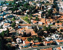
Beit Dagan (Hebrew: בֵּית דָּגָן, lit. "House of Grain") is a town and local council in the Central District of Israel. Located adjacent to Rishon LeZion, it had a population of 7,099 in 2015. It was awarded local council status in 1958.
Contents
- Map of Beit Dagan Israel
- Bnf vs navy seals 22 8 15 beit dagan airsoft israel
- History
- Climate
- Transportation
- References
Map of Beit Dagan, Israel
Bnf vs navy seals 22 8 15 beit dagan airsoft israel
History
Beit Dagan was founded in 1948 at the site of the Arab village Bayt Dajan by Yemenite and North African immigrants. It is probably situated in the area of Biblical Beit Dagon, a village in the tribe of Judah (Joshua 15:41).
The Volcani Institute is located in Beit Dagan.
Climate
Beit Dagan is the home of the Israel Meteorological Service.
Beit Dagan has a Mediterranean climate with hot and rainless summers, and with cold and rainy winters. Springs and autumns are cool to warm. Humidity is high during winter and low during summer, which makes summers rainless and hot, between average high of 30.8 °C (87.4 °F) and average low of 20.4 °C (68.7 °F). Winters are rainy and mild, between average high of 18.5 °C (65.3 °F) and average low of 7.6 °C (45.7 °F). Beit Dagan receives 550.5 mm (21.7 in) of precipitation per year and there are only 7 months of heavy rain.
Transportation
Beit Dagan's main transportation hub is the Beit Dagan Junction (actually located in Rishon LeZion), between highway 44 and route 412, serving as a bus terminal for lines to Rishon LeZion, Tzrifin, Ashkelon, Tel Aviv, Petah Tikva, Rehovot, etc.
The large Shapirim Interchange (intersection of Highway 1 and Route 412) is located on the eastern side of town.