
Population 1,098 (2011) Sovereign state United Kingdom Local time Wednesday 1:57 PM District Bassetlaw | OS grid reference SK7890 Post town DONCASTER Dialling code 01427 | |
 | ||
Weather 8°C, Wind SW at 19 km/h, 68% Humidity | ||
Beckingham is a village and civil parish in the Bassetlaw district of Nottinghamshire, England, about 3 miles west of Gainsborough, Lincolnshire. According to the 2001 census it had a population of 1,168, reducing to 1,098 at the 2011 Census.
Contents
Map of Beckingham, UK
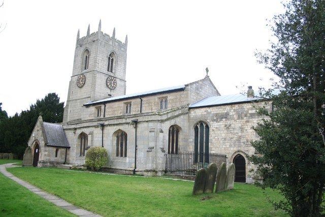
The parish church of All Saints is mostly of the 13th century, though the exterior is apparently 15th century. The west tower has buttresses, battlements, gargoyles and pinnacles. There is a north chancel chapel and sedilia.
A tower windmill was built some time prior to 1840 to the north of the village (grid reference SK772904). The tower was straight-sided. In 1841 the mill had 2 pairs of millstones driven by 4 common sails, described as "self-regulating cloth and rollers to the sails". By 1850 the mill had been fitted with a pair of patent sails, retaining one pair of rollers; these drove 3 pairs of millstones.
Beckingham Marshes
Beckingham Marshes is a RSPB nature reserve. Nearby there is a crude oil and gas production field run by IGas Energy. The wells in the field where fracked using the older less controversial technique.