
Width 3 km (1.9 mi) Population 0 | Length 14 km (8.7 mi) Highest elevation 165 m (541 ft) Elevation 165 m | |
 | ||
Archipelago | ||
Becker Island (Russian: Остров Беккера; Ostrov Bekkera) is an island in Franz Josef Land, Arkhangelsk Oblast, Russian Arctic.
Contents
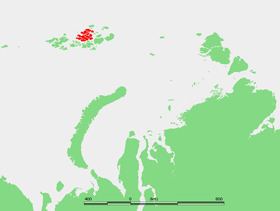
Map of Becker Island, Arkhangelsk Oblast, Russia
Becker Island was named after German civil engineer and entomologist Theodor Becker (1840 - 1928). Becker wrote about the insects in North Siberia as a contribution to the scientific results of Baron Eduard von Toll's Russian Polar Expedition of 1900-1903.
Geography
Becker Island is long and narrow, stretching from East to West. It is located straight south of Rainer Island. Its length is 14 km (8.7 mi) and its average width 3 km (1.9 mi).
The Kupol Surova (Купол Сурова) ice dome covers the western part of the island. The highest point of Becker Island is a 165 m (541 ft) high summit located at the eastern end. The eastern half of this island is unglacierized. The eastern headland, Cape Galkovsky (Mys Galkovskogo) is relatively close to the island's highest point. The western headland is Cape Lopast.