
NRHP Reference # 70000359 Phone +1 406-834-3413 | Built 1805 (expedition) Area 97 ha Added to NRHP 11 February 1970 | |
 | ||
Management Montana Department of Fish, Wildlife and Parks, Bureau of Land Management Similar Clark's Lookout State Park, Beavertail Hill State Park, Lost Creek State Park, Missouri Headwaters State Park, Pirogue Island State Park | ||
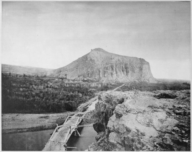
Beaverhead Rock, also known as Point of Rocks, is a rock formation in Montana. It is located on Montana State Highway 41, 14 miles (23 km) south of Twin Bridges of Madison County.
Contents
The rock formation is protected within Beaverhead Rock State Park, and is located above the Beaverhead River.
Beaverhead rock on the l c trail
History
Beaverhead Rock is a rock feature identified in 1805 by Sacagawea, during the Lewis and Clark Expedition, as a landmark not distant from the summer retreat of her nation. According to the Journal of Lewis:
the Indian woman recognized the point of a high plain to our right which she informed us was not very distant from the summer retreat of her nation on a river beyond the mountains which runs to the west. This hill she says her nation calls the Beaver's Head, from a conceived resemblance of its figure to the head of that animal...as it is now all important with us to meet with those people as soon as possible I determined to proceed tomorrow with a small party...and pass the mountains to the Columbia; and down that river until I found the Indians...without horses we shall be obliged to leave a great part of our stores...