
Area 162 ha | ||
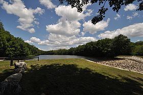 | ||
Cascade trail at beaver brook state park nh
Beaver Brook State Park is an undeveloped public recreation area covering 401 acres (162 ha) in the towns of Windham and Chaplin, Connecticut, United States. The state park encompass Bibbins Pond, also known as Beaver Brook Pond, as well as the acreage north of the pond; its name may derive from a beaver pond once present. Air Line State Park Trail forms the park's northern boundary. The park is a walk-in facility open for hunting and trout fishing, managed by the Connecticut Department of Energy and Environmental Protection.
Contents
HistoryEdit
The park was one of several public recreation areas acquired in the 1950s using funds bequeathed for that purpose by George Dudley Seymour. When the gift was announced in 1955, it was reported that trout pools had already been developed north of Bibbins Pond. The Connecticut State Register and Manual reported the park's acreage at 165 acres in 1955 and 391 acres in 1957. The park achieved its present size of 401 acres by 1960.
Activities and amenitiesEdit
Bibbins Pond, known as Beaver Brook Pond, is the park's central feature, while Beaver Brook runs both north and south of the pond and continues beyond the park limits. Bibbins Pond's 20 acres (8.1 ha) offer a seasonal boat launch for non-motorized watercraft and trout fishing. In 1994, a Connecticut state record brook trout was caught in Beaver Brook Pond by 5-year-old Sean Wozniak, a record that was surpassed in 1998. The park also includes a geocache which can be accessed via three different routes.