
Intercommunality Haute-Bigorre Area 16.7 km² | Region Occitanie Population (2009) 390 | |
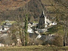 | ||
Beaudéan (Occitan: Beudian) is a French commune in the Hautes-Pyrénées department in the Occitanie region of south-western France.
Contents
- Map of 65710 BeaudC3A9an France
- Geography
- Mapping
- Toponymy
- Administration
- Judicial and administrative proceedings
- Demography
- Civil heritage
- Religious heritage
- Notable people linked to the commune
- References
Map of 65710 Beaud%C3%A9an, France
The inhabitants of the commune are known as Beaudéannais or Beaudéannaises.
Geography
Beaudean is located at the mouth of the Lesponne valley and the Campan valley in the inter-communal cooperative of Haute-Bigorre some 20 km south by south-east of Tarbes and 5 km south of Bagnères-de-Bigorre. Access to the commune is by the D935 road from Pouzac in the north which passes through the eastern tip of the commune and the village and continues south-east to Campan. The D29 branches off the D935 in the commune and goes along the length of the commune south-west to end in Chiroulet. Apart from the village there is the hamlet of Serris. The commune is mixed forest and farmland in the north and rugged forested mountains in the south.
The Adour river forms the north-eastern border of the commune as it flows north-west eventually joining the Atlantic ocean at Boucau. The Adour de Lesponne flows from the south-west of the commune, forming much of the western border as it flows north-east, gathering tributaries such as the Ruisseau du Brouilh (which forms the southern border of the commune), the Ruisseau de Narbios, the Hourquet, and the Ruisseau de Hount Hérède, to join the Adour at the eastern corner of the commune. The Serris river flows north-east through the commune and the village to join the Adour. The Ruisseau de Binaros forms most of the eastern border of the commune as it flows north to join the Adour de Lesponne in the narrow "neck" of the commune.
Mapping
A list of online mapping systems can be displayed by clicking on the coordinates (latitude and longitude) in the top right hand corner of this article.
Toponymy
Historical names:
Beaudéan appears as Beaudean on the 1750 Cassini Map and the same on the 1790 version.
Beaudéan comes from the name of a domain. The Germanic personal name Bald-win (Latinised as Baldinus) with the suffix -anum.
Administration
List of Successive Mayors
(Not all data is known)
Judicial and administrative proceedings
Beaudéan falls within the area of the Tribunal d'instance (District court) of Tarbes, the Tribunal de grande instance (High Court) of Tarbes, the Cour d'appel Court of Appeal of Pau, the Tribunal pour enfants (Juvenile court) of Tarbes, the Conseil de prud'hommes (Labour Court) of Tarbes, the Tribunal de commerce (Commercial Court) of Tarbes, the Tribunal administratif (Administrative tribunal) of Pau, and the Cour administrative d'appel (Administrative Court of Appeal) of Bordeaux
Demography
In 2012 the commune had 391 inhabitants. The evolution of the number of inhabitants is known from the population censuses conducted in the commune since 1793. From the 21st century, a census of communes with fewer than 10,000 inhabitants is held every five years, unlike larger communes that have a sample survey every year.
Sources : Ldh/EHESS/Cassini until 1962, INSEE database from 1968 (population without double counting and municipal population from 2006)
Civil heritage
Religious heritage
The Church of Saint Martin (15th century) is registered as an historical monument. is It is characterized by a bell tower with four corbelled turrets. The Church contains several items that are registered as historical objects: