
Named for Bears Paw Mountains | Primary Slate | |
 | ||
Thickness Up to 350 meters (1,150 ft) | ||
gem ammonite placenticeras meeki late cretaceous bearpaw formation st mary s river alberta
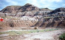
The Bearpaw Formation, also called the Bearpaw Shale, is a geologic formation of Late Cretaceous (Campanian) age. It outcrops in the U.S. state of Montana, as well as the Canadian provinces of Alberta and Saskatchewan, and was named for the Bear Paw Mountains in Montana. It includes a wide range of marine fossils, as well as the remains of a few dinosaurs. It is known for its fossil ammonites, some of which are mined in Alberta to produce the organic gemstone ammolite.
Contents
- gem ammonite placenticeras meeki late cretaceous bearpaw formation st mary s river alberta
- Lithology and depositional environment
- Relationship to other units
- Fauna
- References
gem ammonite placenticeras meeki late cretaceous bearpaw formation st mary s river alberta
Lithology and depositional environment
The formation was deposited in the Bearpaw Sea, which was part of the Western Interior Seaway that advanced and then retreated across the region during Campanian time. It is composed primarily of dark grey shales, claystones, silty claystones and siltstones, with subordinate silty sandstones. It also includes bedded and nodular concretions (both calcareous and ironstone concretions) and thin beds of bentonite. As the seaway retreated toward the southwest, the marine sediments of the Bearpaw became covered by the deltaic and coastal plain sediments of the overlying formations.
Relationship to other units
The Bearpaw Formation conformably overlies the Dinosaur Park Formation of the Belly River Group in central Alberta, and the Judith River Formation in the plains to the east and Montana. It is overlain by the Horseshoe Canyon Formation in central Alberta; by the Blood Reserve Formation and the St. Mary River Formation in southern Alberta; by the Eastend Formation in southern Saskatchewan; and by the Fox Hills Formation in Montana. To the east, it merges into the Pierre Shale.
Fauna
The Bearpaw Formation is famous for its well-preserved ammonite fossils. These include Placenticeras meeki and Placenticeras intercalare, and the baculite Baculites compressus, some of which are mined south-central Alberta to produce the organic gemstone ammolite.
Other fossils found in this formation include many types of shellfish, bony fish, sharks, rays, birds, and marine reptiles like mosasaurs, plesiosaurs and sea turtles. Dinosaur remains have occasionally been discovered, presumably from carcasses that washed out to sea.