
Topo map USGS Valle Crucis Prominence 329 m | Elevation 1,586 m Mountain range Blue Ridge Mountains | |
 | ||
Similar Peak Mountain, Flattop Mountain, Snake Mountain, Rich Mountain, Grandmother Mountain | ||
Christmas at bear s paw ranch quick wallhanging candy cane lane
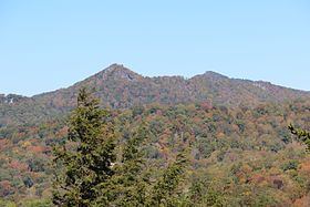
Hanging Rock, also known as Bear's Paw (Yonah‑wayah in Cherokee), is a mountain in the North Carolina High Country, next to the town of Seven Devils. It is along the Avery and Watauga border. Its elevation reaches 5,203 feet (1,586 m). The mountain generates feeder streams for the Elk and Watauga rivers.
Contents
- Christmas at bear s paw ranch quick wallhanging candy cane lane
- Map of Hanging Rock Shawneehaw NC 28604 USA
- Knit with elizzza knitting stitch bear s paws video 01 lace stitch
- References
Map of Hanging Rock, Shawneehaw, NC 28604, USA
In 2008, Bear Paw State Natural Area was established on the mountain by the North Carolina General Assembly. The High Country Conservancy acquired the initial 350 acres (1.4 km2) for the state, and the park now encompasses 384 acres (1.55 km2). The natural area is located just north of Grandfather Mountain State Park, and it protects Hanging Rock Ridge and the headwaters of Dutch Creek. It is managed by Elk Knob State Park.
Knit with elizzza knitting stitch bear s paws video 01 lace stitch
References
Bear's Paw Wikipedia(Text) CC BY-SA