
Elevation 3,490 m Listing Ultra-prominent peak | Last eruption Unknown Prominence 2,400 m | |
 | ||
Similar Taftan, Qal'eh Hasan Ali, Sharat Kovakab, Sahand, Ile des Cendres | ||
Bazman (Persian: بزمان, also known as Kuh-e Bazman) is a stratovolcano in a remote desert region of Sistan and Baluchestan Province in south-eastern Iran. A 500-m-wide crater caps the summit of the dominantly andesitic-dacitic volcano, the flanks of which are covered by monogenetic centres especially to the northwest. Bazman is a geologically young volcano which was made in the Quaternary, with the oldest dated rocks being 11.7 million years old and the youngest 0.6 million years. Although no historic eruptions have been reported from Bazman, it does contain fumaroles. Thus Bazman may be regarded as dormant, rather than extinct. Its satellite cones have been the source of basaltic lava flows.
Contents
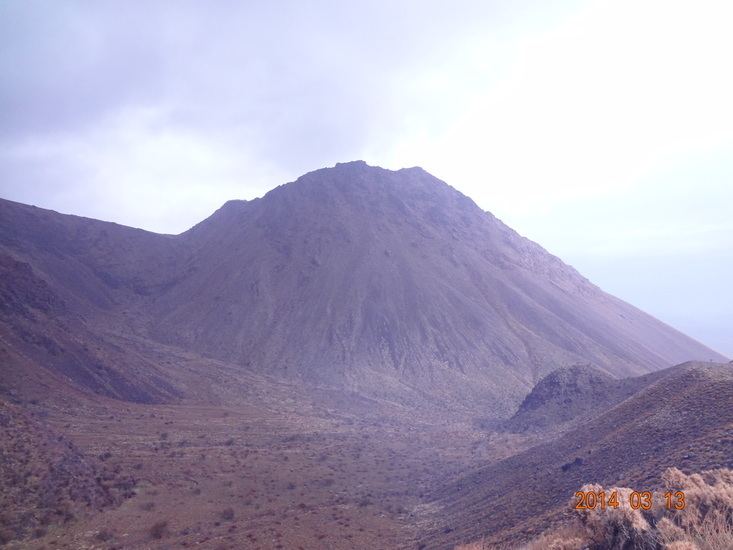
Map of Bazman, Iran
Bazman volcano is part of a volcanic arc in southeastern Iran, the Makran volcanic arc. At this arc, shallow subduction has generated an arc of volcanic activity which includes Bazman, Taftan and Koh-i-Sultan volcanoes. Bazman has been affected by heavy erosion. The flanks of the volcano are covered with debris coming from the volcano. A Cretaceous pluton is also associated with Bazman and has been investigated for the possibility of mining.
Geography and geology
Bazman is also known as Kuh-i-Zindeh ("Mountain of the Living One"), after a saint, Khizr-as-Sallam. Yet another name is Kuh-i-Naushada, although they are sometimes considered to be separate mountains. The mountain was climbed in 1896 by Percy Sykes and Brazier Creagh; By 1906 its volcanic nature was known to geologists. It is located 420 kilometres (260 mi) away from the Arabian Sea, and 120 kilometres (75 mi) northnorthwest of Bampur.
Regional setting
Iran contains two major mountain ranges, the Alborz in northern Iran and Zagros in western Iran. Each range is associated with a major suture zone, the Alborz-Kopeh Dag and the Bitlis-Zagros sutures respectively. These mountain chains surround Central Iran, in whose southern part lies the Lut block and Bazman. Tectonically, southern central Iran does not follow the typical Alpide geological patterns insofar as faults are rare and the folds in the crust are broad. The Bazman area is covered by volcanic rocks of Tertiary age. The foreland of the mountain massifs such as the Bazman massif are affected by tectonic subsidence. A major Tertiary volcanic belt, analogous to the Indonesian volcanic arc, crosses Iran behind the Zagros.
South of Bazman volcano lies the broad Jaz Murian depression. To the south of this depression the Makran area separates the Arabian sea from inner Iran. The Makran area is geologically subdivided into the Inner Makran series which includes ophiolitic melange and the Coastal Makran Series. A phase of subduction commenced in the Pliocene-Pleistocene, probably after earlier phases of subduction. This subduction has resulted in the formation of a volcanic complex including Bazman that stretches 150 kilometres (93 mi) east-west and reaches a width of 100 kilometres (62 mi), as well as earthquake activity including the 1945 Makran earthquake, but overall earthquake activity in the Makran is low, probably due to the effect of sediments in the trench. A large accretionary prism formed directly behind the trench, in the trench the subduction occurs at a pace of 2 centimetres per year (0.79 in/year). There is no evidence of a Wadati-Benioff zone beneath the Makran. Bazman has been grouped with Taftan volcano also in Iran and Koh-i-Sultan in Pakistan, of which only Taftan is considered active. This arc is over 600 kilometres (370 mi) away from the trench, indicating that the subduction is very shallow. Within this arc, Bazman is located at the edge between the actual subduction and the continental collision zone. Bazman is also considered part of a 1,700 kilometres (1,100 mi) long volcanic belt named the Sahand-Bazman belt that extends from northwest to southeast and is accompanied by Cenozoic volcanic rocks including plutons. Bazman is sometimes considered to be part of a volcanic complex with the neighbouring Shahsavaran volcanic field.
Local setting
Bazman is one among about nine volcanic centres in Iran that have had Quaternary eruptions. Other volcanoes are Damavand which is also Asia's highest volcano, Taftan, Qal'eh Hasan Ali, Sabalan and Sahand volcanoes. Most of these volcanoes are part of a volcanic belt named Dokhtar-Urmiah. With the exception of reports of possible lava flows at Taftan, none of these volcanoes have been reportedly active during historical times. Older volcanic activity within this belt has generated a number of Cu porphyry deposits.
Bazman volcano is 11,500 feet (3,500 m) high, rising high above the surrounding terrain, and has steep slopes. At the top of the volcano lies a summit crater. This crater is well conserved and it has a diametre of 500 metres (1,600 ft). On the north flank, a northbound lava flow with prominent levees that eventually splits into a northwestern and northeastern arm was discharged by a steep lava cone. Other viscous lava flows have been erupted from satellite cones. The volcano is constructed on top of the Lut block, which reaches a thickness of 40 kilometres (25 mi). Quaternary sediments are buried beneath Bazman's eruption products. The Moho beneath Bazman is approximately 48–50 kilometres (30–31 mi) deep. The area around Bazman is remote.
A field of monogenetic volcanoes is found northwest of Bazman. These include broad and shallow craters with diameters of 800 metres (2,600 ft) with pyroclastic rocks, cryptodomes with diameters of up to 3 kilometres (1.9 mi) and heights of 75 metres (246 ft), scoria cones reaching a height of 300 metres (980 ft) with lava flow fields and individual lava flows. The varying state of erosion of these volcanoes indicates they formed over many millennia; some have been worn down to their feeding dykes.
Bazman has no recorded historical eruptions but fumarolic activity has been reported, as well as ongoing surface deformation. Bazman is considered to be occasionally smoking. Hot springs containing iron and sulfur are other signs of ongoing volcanism; Bazman has been considered a potential site for development of geothermal energy, with a surface area of 8,356 square kilometres (3,226 sq mi). In 1960, Bazman together with Taftan was considered a volcano with sporadic historic activity, while a different report in 1975 considered the volcano extinct. Potassium-argon dating of basalts from the volcano has yielded ages of 4.6 and 0.6 million years ago. These dates were obtained on the monogenetic cones; zircons directly from Bazman rocks are dated 7.5 ± 0.1 and 5.9 ± 0.2 million years ago by uranium-lead dating, along with other ages of 8–6 million years ago from other zircons around Bazman. A third date is of 11.7 million years ago. Another report in 1981 suggested that isotopic ages also indicate historic activity.
Bazman volcano is constructed by dacite, but andesite has also been mentioned. Minor amounts of rhyolite have also been reported. Overall rock samples range from basalt to rhyolite in composition and are mostly of calc-alkaline composition. The satellite cones have erupted olivine-containing basalts. The mountain's flanks are covered by a layer of detritus, burying most of the flanks to over 2,135 metres (7,005 ft) of altitude. Most of this detritus is erosional in nature, but pyroclastic rocks created by explosive activity and hot avalanches of extruded lava also contribute. 120 metres (390 ft) thick olivine basalt found in the Jaz Murian depression may also come from Bazman. Basalt has also been found at one cryptodome. North of Bazman, andesites of Miocene-Eocene age are partly buried beneath the volcano. Carboniferous and Permian metamorphic rocks form the oldest basement at Bazman.
Petrological analysis at the monogenetic volcanoes around Bazman has indicated porphyritic basalts containing clinopyroxene, olivine and plagioclase, with an isolated report of hornblende. The rocks have medium K content, lower than that of Taftan and Koh-i-Sultan. This may reflect differences in the subduction beneath Bazman and the other two volcanoes. Composition data are typical of volcanic island arc rocks, with some samples have element ratios more akin to ocean island basalts. Lithosphere modified by the subduction may be the origin of the magmas that formed the monogenetic cones. On the basis of its composition, the environmental conditions under which one of the samples formed have been estimated, the temperature being c. 1,400 °C (2,550 °F) and a minimum depth of about 76 kilometres (47 mi).
A mining area is associated with Bazman and more precisely with Paleozoic-Mesozoic rocks including a c. 70 million years old granite pluton. This late Cretaceous pluton is localized south of Bazman volcano. According to other reports its rocks are also exposed on the northern side of Bazman. Various hydrothermal and skarn alterations have generated mineral deposits that include silver, gold, copper, lead, magnesium, molybdenum, and zinc, and minor amounts of tungsten and possibly of vanadium. The Chahnali epithermal gold deposit is close to the volcano.
The area of Bazman is affected by rain erosion. Sheet floods such as those that occurred in 1976 are principal agents. Together with other kinds of erosion such as frost and salt weathering, these have formed a pediplain terrain with inselbergs being left, especially where harder rocks are found. Pebbles eroded from Bazman have been transported to the terrains of the Jaz Murian depression south of Bazman. The effects of this erosion have mantled the volcano with debris locally known as "dasht", reaching distances of over 30 kilometres (19 mi) from the vent. With the exception of the Ziyarat valley on Bazman's southern flank, the area around Bazman is arid and uninhabited.