
Age of rock Holocene Last eruption 850 CE ± 50 years | Mountain type Volcanic field Elevation 670 m | |
 | ||
Similar Jebel Umm Arafieb, Jebel Dair, Borawli, Gufa Volcano, Borale Ale | ||
The Bayuda (or Baiyuda) Volcanic field (BVF) are crater-like landforms in NE Sudan 300 km north of Khartoum.
Contents
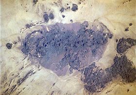
Map of Bayuda Volcanic Field, Sudan
Geography
The BVF is located in the north of the Bayuda Desert in the bend of the Nile between the Fourth and the Fifth Cataract. The main volcanic field is 48 km long and 11 km wide covering an area of about 480 km2 and extending in a NW direction from 18.28 N, 32.92 E. to 18.43 N to 32.50 E.
Geology
The BVF has a very long geological history as it was a part of the Gondwanaland. It comprises at least 57 Cinder cones, 15 Maars and large Lava fields. The volcanoes are small and composed of basaltic lavas and Tephra. Each of the composite volcanoes passed through a stage of pyroclastic cone-building followed by a period of lava extrusion which usually resulted in the breaching of the cone.
Maar-like craters
Due to their lack of erosion the maar-like explosion craters are considered of recent, Pleistocene or Holocene, origin. The largest one, Hosh ed Dalam, is 1.3 km wide, and approximately 500 m deep. The El Muweilih or Atrun Crater is certainly the best known one. El Muweilih means The Salty Place and refers to a small saline lake on the crater floor from where natron-rich clay is dug out and dried by local nomads.