
Arabic بيت نتّيف Subdistrict Hebron Date of depopulation 21 October 1948 | Name meaning The house of Nettif Palestine grid 149/122 | |
 | ||
Cause(s) of depopulation Military assault by Yishuv forces Current localities Netiv HaLamed-Heh, Aviezer, Neve Michael | ||
Bayt nattif
Bayt Nattif or Beit Nattif (Arabic: بيت نتّيف, Hebrew: בית נתיף) was a Palestinian Arab village, located some 20 kilometers (straight line distance) southwest of Jerusalem, midway on the ancient Roman road between Beit Guvrin and Jerusalem, and 21 km northwest of Hebron. During the British Mandate it was part of the Hebron Subdistrict. Bayt Nattif was depopulated during the 1948 Arab–Israeli War on October 21, 1948 under Operation Ha-Har.
Contents
- Bayt nattif
- Roman and Early Byzantine periods 63 BCE 4th century CE
- Ottoman period 1517 1917
- British Mandate 1917 1948
- 1948 war and depopulation
- Israeli rule since 1948
- References
Known by the Romans as Bethletepha, the original Arab name was Bayt Lettif.
The village lay nestled on a hilltop, surrounded by olive groves and almonds, with woodlands of oak and carobs overlooking Wadi es-Sunt (the Elah Valley) to its south.
In 1945 Bayt Nattif had a population of 2,150 Muslims. It contained several shrines, including a notable one dedicated to al-Shaykh Ibrahim. Roughly a dozen khirbas lay in the vicinity.
Roman and Early Byzantine periods (63 BCE - 4th century CE)
Bayt Nattif stood on the much-travelled ancient road connecting Eleutheropolis (Beit Guvrin) with Jerusalem, about midway between the two towns.
Bayt Nattif was known under the Romans as Bethltepha, more commonly known by its Greek spelling, Bethletephon.
The city had been assigned the status of toparchy, one of eleven toparchies or prefectures in Judaea given certain administrative responsibilities.
According to Josephus, the city was sacked under Vespasian and Titus, during the first Jewish uprising against Rome. During the 12th year of the reign of Nero, when the Roman army had suffered a great defeat under Cestius, with more than five-thousand foot soldiers killed, the people of the surrounding countryside feared reprisals from the Roman army and made haste to appoint generals and to fortify their cities. Generals were at that time appointed for Idumea, namely, over the entire region immediately south and south-west of Jerusalem, and which incorporated within it the towns of Bethletephon, Betaris, Kefar Tobah, Dora and Marissa. This region was called Idumea on account of it being a region inhabited largely by the descendants of Esau (Edom) who made themselves proselytes to Judaism during the time of John Hyrcanus.
Based upon archaeological finds that were discovered in Bayt Nattif, the city was still an important site in the Late Roman period. The place was now inhabited by Roman citizens and veterans, who settled the region as part of the Romanisation process that took place in the rural areas of Judaea after the Bar Kokhba war.
The "Beit Nattif lamp" is a type of ceramic oil lamp found during the archaeological excavation of two cisterns at Bayt Nattif in southern Judaea. Based on the discovery of unused oil lamps and molds, it is believed that during the late Roman or Byzantine period the village manufactured pottery, possibly selling its wares in Jerusalem and Beit Guvrin. During a 2014 dig at Khirbet Shumeila, 1 km north of Beit Nattif, stone molds for 3rd-4th century "Beit Nattif lamps" were found within the remains of a large villa.
Ottoman period (1517 – 1917)
In 1596, Bayt Nattif was listed among villages belonging to the nahiya Quds, in the administrative district Liwā` of Jerusalem, in a tax ledger of the "countries of Syria" (wilāyat aš-Šām) and which lands were then under Ottoman rule. During that year, Bayt Nattif was inhabited by one-hundred and four Muslim households. The Ottoman authority levied a 33.3% taxation on agricultural products produced by the villagers (primarily on wheat, barley, olives, sesame seeds and grapes, among other fruits), besides a marriage tax and supplement tax on goats and beehives. Total revenues accruing from the village of Bayt Nattif for that year amounted to 12,000 akçe.
In 1838 Edward Robinson visited, and remarks that their party was very well received by the villagers. He further noted that the villagers belonged to the "Keis" faction. By the mid-19th century, a rift had divided families in the region over control of the district Bani Hasan, until at length it broke out into actual fighting between the Keis (Qays) faction, on the one side, and the Yaman faction, on the other. Meron Benvenisti, writing of this period, says that Sheikh 'Utham al-Lahham waged "a bloody war against Sheikh Mustafa Abu Ghosh, whose capital and fortified seat was in the village of Suba." In 1855, Mohammad Atallah in Bayt Nattif, a cousin of 'Utham al-Lahham, contested his rule over the region. In order to win support from Abu Ghosh, Mohammad Atallah gave his allegiance to the Yaman faction. This is said to have enraged 'Utham al-Lahham. He raised a fighting force and fell on Bayt Nattif on 3 January 1855. The village lost 21 dead. According to an eyewitness description by the horrified British consul, James Finn, their corpses were terribly mutilated.
In 1863 Victor Guérin visited twice. The first time he visited he estimated that the village contained about one thousand inhabitants. He further noted that the houses were crudely built, one of them, which was assigned to the reception of foreigners, the al-Medhafeh, was a square tower. Above the entrance of the al-Medhafeh was a large block for lintel, featuring elegant mouldings, Guérin assumed it came from an ancient destroyed monument. Many other ancient stones were embedded here and there in private homes. Two wells, several cisterns and a number of silos and stores carved in the rock, and in continued use, were also ancient.
An Ottoman village list of about 1870 found 66 houses and a population of 231, though the population count included men only.
In 1883, the Palestine Exploration Fund's Survey of Western Palestine described Bayt Nattif as being "a village of fair size, standing high on a flat-topped ridge between two broad valleys. On the south, about 400 feet below, is a spring (`Ain el Kezbeh), and on the north a rock-cut tomb was found. There are fine olive-groves round the place, and the open valleys are very fertile in corn."
British Mandate (1917 – 1948)
For all practical purposes, the British inherited from their Turkish counterparts the existing laws in regard to land tenures as defined in the Ottoman Land Code, to which laws there was later added subsidiary legislation. At the time of the British occupation the land tax was collected at the rate of 12 1/2 per cent. of the gross yield of the land. Crops were assessed on the threshing floor or in the field and the tithe was collected from the cultivators. In 1925, additional legislation provided that taxation on crops and other produce not exceed 10%. In 1928, as a measure of reform, the Mandate Government of Palestine began to apply an Ordinance for the "Commutation of Tithes," this tax in effect being a fixed aggregate amount paid annually. It was related to the average amount of tithe (tax) that had been paid by the village during the four years immediately preceding the application of the Ordinance to it.
In the 1922 census of Palestine conducted by the British Mandate authorities, Bayt Nattif had a population of 1,112, all Muslims, increasing in the 1931 census to 1,649, still all Muslim, in a total of 329 houses (which figure includes houses built in the nearby ruin, Khirbet Umm al-Ra’us).
In 1934, Dimitri Baramki of the Mandate Department of Antiquities directed the excavation of two cisterns in the village of Bayt Nattif which produced mostly ceramic ware dating from between the 1st and 3rd centuries CE.
By 1945, the population had increased to 2,150 Muslims. In 1944/45, a total of 20,149 dunums were allocated to cereal grains in the adjacent lowlands; 688 dunums were irrigated or used for orchards, while 162 dunams were built-up (urban) areas.
1948 war and depopulation
In the proposed 1947 UN Partition Plan, it was designated as part of the Arab state.
As hostilities broke out in the wake of the publication of the plan, Yohanan Reiner and Fritz Eisenstadt, military advisors of David Ben-Gurion proposed, on December 18 1947, that any Arab attack be met with a decisive blow, consisting of the 'destruction of the place or chasing out the inhabitants and taking their place.' Such proposals were mulled and shelved, -one participant likening such proposals to the destruction of Lidice, but in January 1948, a Jerusalem District HQ document entitled 'Lines of Planning for Area Campaigns for the Month of February 1948, foresaw taking steps to secure the Jerusalem-Tel Aviv route. In this document one measure consisted of 'the destruction of villages or objects dominating our settlements or threatening our lines of transportation,' and among the objectives of the plan the destruction of the southern bloc of Beit Nattif was envisaged.
The official Jewish account (The "History of Haganah") alleges that the village of Bayt Nattif took part in the killing of thirty-five Jewish fighters (see the Convoy of 35, the "Lamed-Heh") who were en route with supplies to the besieged block of kibbutzim of Gush Etzion, on January 16, 1948. However, reports from the New York Times correspondent indicate that the convoy took a wrong turn, and ended up in Surif. The Arab version is that the convoy had attacked Surif deliberately, and had held it for an hour before being driven out. After this, the Haganah mounted a "punitive" attack on Bayt Nattif, Dayr Aban and Az-Zakariyya. In late January 1948, the Haganah's Jerusalem HQ suggested "the destruction of the southern block of Bayt Nattif" in order to secure transportation along the Tel-Aviv-Jerusalem highway.
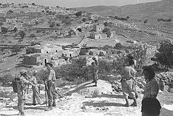
The Israeli Air Force bombed the area of Bayt Nattif on October 19, 1948, which started panic flights from Bayt Nattif and Bayt Jibrin. Bayt Nattif was depopulated during the 1948 Arab-Israeli War on October 21, 1948 under Operation Ha-Har, by the Fourth Battalion of the Har'el Brigade. There are conflicting reports about its conquest, one Palmah report says that the villagers "fled for their lives", while a Haganah report says that the village was occupied "after some light resistance."
During late 1948, the IDF continued to destroy conquered Arab villages, in order to block the villagers return. Among these destroyed villages was Bayt Nattif which, based on Jewish sources, was completely destroyed as a punitive measure for the village's involvement in the detection and massacre of the Convoy of the thirty-five. There are also conflicting reports about which other villages were destroyed with it; one report says that Dayr Aban was destroyed with it, while another report says that Dayr al-Hawa was destroyed with it.
On 5 November, the Harel Brigade raided the area south of Bayt Nattif, driving out any Palestinian refugee they could find.
Israeli rule since 1948
Netiv HaLamed-Heh was built on village land in 1949, while Aviezer and Neve Michael were built on village land in 1958.
Today, the land whereon was once built Bayt Nattif comprises what is now called The Forest of the Thirty-Five (Hebrew: יַעֲר הַל"ה) and is maintained by the Jewish National Fund. Erik Ader, former Dutch ambassador to Norway and the son of Bastiaan Jan Ader who is memorialized in the forest as one of the Righteous Among the Nations for saving 200 Jews from the Holocaust, has asked that his father's name be removed as a protest against what Ader called "the ethnic cleansing" of Palestinians. In response, the Jewish National Fund expressed its respect for the actions of Ader’s parents, stating that the monument was legally constructed on state-owned lands.