
Population 0 Elevation 9.9 m | Highest elevation 11 m (36 ft) Area 1 ha Archipelago Izu Islands | |
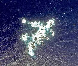 | ||
Bayonnaise Rocks (ベヨネース列岩, Beyonēsu-retsugan) is a group of volcanic rocks in the Philippine Sea about 408 kilometres (254 mi) south of Tokyo and 65 kilometres (40 mi) south-southeast of Aogashima, in the south portion of the Izu archipelago, Japan. The rocks were discovered by the French corvette Bayonnaise in 1846.
Contents
Map of Bayonnaise Rocks
Geography
The rocks are the exposed portion of the western ridge of a submarine volcanic caldera, approximately 9 kilometres (5.6 mi) in diameter at a depth of approximately 1,000 metres (3,300 ft). The above sea-level portion has a surface area of approximately 0.01 square kilometers, with a summit height of 11 metres (36 ft). The caldera is known to have erupted in 1896, 1906, 1915, 1934, 1946, 1952-1953, 1954, 1955, 1957, 1958, 1959, and 1960. The last known submarine eruption of the caldera was in 1970, which discolored the local water.
On the northeast rim of the same caldera 12.8 kilometres (8.0 mi) to the east of the Bayonnaise Rocks is a submerged reef named Myōjin-shō (明神礁), which is a post-caldera cone with a depth of approximately 50 metres (160 ft). During a submarine volcanic eruption of 17 September 1952, an ephemeral island was formed, with a height of 10 metres (33 ft), which was created and destroyed several times by volcanic activity until completely disappearing on 3 September 1953.
The vegetation is sparse among the Bayonnaise Rocks. The islands are a resting place for migratory birds. Located in the Kuroshio Current, the area has abundant sea life, and is popular with sports fishermen.