
OS grid reference SD2872 Dialling code 01229 UK parliament constituency Barrow and Furness | Sovereign state United Kingdom Postcode district LA12 District South Lakeland Civil parish Aldingham | |
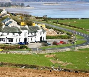 | ||
Baycliff is a village in the South Lakeland District of Cumbria in England. Historically in Lancashire, it is situated 3 miles (4.8 km) south of Ulverston, in the civil parish of Aldingham. At the centre is a village green, and many of its buildings date from the 17th and 18th centuries. There are two public houses, the Farmer's Arms and the Fisherman's Arms, situated close to the green.
Contents
Map of Baycliff, Ulverston, UK
History
In the past Baycliff, originally spelled Baycliffe, was a fishing and farming community. The industries of iron mining and local white stone quarrying provided employment for the men of the village. The iron was shipped to Backbarrow. It was the birthplace in about 1619 of the prominent Quaker preachers Alice Curwen (maiden name unknown) and her husband Thomas Curwen.
Limestone
Baycliff limestone is still quarried; the quarry beds produce two distinct stones. Lord is oatmeal coloured with dark cream markings; Caulfield is a buff stone with light coffee mottling. It is a versatile material, used to create distinctive, durable floors and attractive paving schemes and is used in landscaping designs.