
Area 24.7 km² | Intercommunality Pays de Chambord Local time Tuesday 3:00 PM | |
 | ||
Weather 7°C, Wind W at 29 km/h, 83% Humidity | ||
Bauzy is a French commune in the Loir-et-Cher department in the Centre region of central France.
Contents
- Map of 41250 Bauzy France
- Geography
- Mapping
- Toponymy
- Administration
- Population
- Distribution of age groups
- Civil heritage
- Religious heritage
- Personalities
- References
Map of 41250 Bauzy, France
The inhabitants of the commune are known as Bauziens or Bauziennes.
Geography
Bauzy is located in the heart of Sologne some 20 km south-east of Blois, 40 km south-west of Orléans, and 40 km north-east of Vierzon. Access to the commune is by the D60 road from Bracieux in the north-west which passes through the heart of the commune and the village and continues south-east to Vernou-en-Sologne. Apart from the village there is the hamlet of La Boulaie in the south-east. The commune is mixed forest and farmland.
The commune is dotted with many small lakes including the Étang d'Avaray, the Étang de l'Oie, and the Étang Saulier plus numerous others. The Beuvron river flows through the north-east of the commune from south-east to north-west and continues to join the Loire at Candé-sur-Beuvron. The Bonne Heure stream flows through the middle of the commune and the village from south-east to north-west where it joins the Beuvron at Bracieux. Many small tributaries feed the Bonne Heure from the numerous lakes.
Mapping
A list of online mapping systems can be displayed by clicking on the coordinates (latitude and longitude) in the top right hand corner of this article.
Toponymy
Bauzy comes from the Low Latin Balaesiacus and Balaesius and its variant Valesisus and the possessive suffix -acus giving "Domain of Balaesiacus.
Bauzy was mentioned as: Bauzi in January 1365; Bauzy and Bauzi in February 1365 and January 1365; Bauzy in February 1365; and Bauzy en Sologne on 24 July 1376.
The Parish was split up for the creation of the Parish of Fontaines-en-Sologne.
Bauzy appears as Bauzy on the 1750 Cassini Map and the same on the 1790 version.
Administration
List of Successive Mayors
(Not all data is known)
Population
In 2010 the commune had 264 inhabitants. The evolution of the number of inhabitants is known from the population censuses conducted in the commune since 1793. From the 21st century, a census of communes with fewer than 10,000 inhabitants is held every five years, unlike larger communes that have a sample survey every year.
Sources : Ldh/EHESS/Cassini until 1962, INSEE database from 1968 (population without double counting and municipal population from 2006)
Distribution of age groups
The population of the town is relatively old. The ratio of persons above the age of 60 years (22.4%) is higher than the national average (21.6%) but less than the departmental average (26.3%). As for national and departmental allocations, the female population of the town is greater than the male population The rate (50.6%) is similar to the national rate (51.6%).
Percentage Distribution of Age Groups in Bauzy and Loir-et-Cher Department in 2010
Sources:
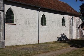
Civil heritage
The commune has a number of buildings and sites that are registered as historical monuments:
Religious heritage
The commune has several religious buildings and sites that are registered as historical monuments:
The church contains a large number of items that are registered as historical objects. For a complete list including links to descriptions (in French) and photos click here.