
Population 107 (2011 census) Civil parish Baulking Area 6.38 km² Dialling code 01367 | OS grid reference SU3190 Sovereign state United Kingdom Local time Tuesday 1:33 PM UK parliament constituency Wantage | |
 | ||
Weather 5°C, Wind SW at 19 km/h, 81% Humidity | ||
Baulking or Balking is a village and civil parish about 3.5 miles (5.6 km) southeast of Faringdon in the Vale of White Horse district of Oxfordshire. It was part of Berkshire until the 1974 Boundary Changes transferred it to Oxfordshire.
Contents
Map of Baulking, UK
Topography
The parish is bounded to the north and north-west by the River Ock, to the south by its tributary Stutfield Brook and to the east by field boundaries. The village is arranged along a large, elongated village green running north–south, on the side of a slight rise of land bounded on two sides by a bend in the river.
History
Balking is an ancient form of the toponym, dating from the 10th century. Other forms from the same century were Bedelacing and Bedelakinges. 12th-century forms included Badeleking and Badeking. Further forms were Batheleking in the 13th century, Bauking in the 16th century and Bawlkin in the 17th century.
Manor
In AD 948 King Eadred gave five hides of land at Baulking to his servant Cuthred, and it was said that Cuthred gave the land to the Benedictine Abingdon Abbey. By 1187 the manor had passed to the lords of Kingston Lisle, with whom it remained until the 20th century.
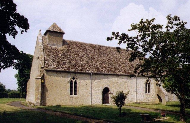
Church
The Grade-I-listed Church of England parish church of Saint Nicholas was built at the beginning of the 13th century as a dependent chapel of Uffington. The chancel has Early English Gothic lancet windows. In the 14th century diagonal buttresses were added to the church and two Decorated Gothic windows were added in the south wall of the nave. The Perpendicular Gothic window in the north wall of the nave was added late in the 15th century. The oak pulpit is Jacobean and came from Grittleton in Wiltshire. The nave roof is also Jacobean. St. Nicholas' Communion plate includes a chalice made in 1583.
Baulking was made an ecclesiastical parish separate from Uffington in 1846. St. Nicholas' is now once again part of the Uffington Benefice, along with the parishes of Shellingford and Woolstone.
History
Baulking was an ancient market town, with market day on Thursday. In 1219 the market was changed to Tuesday and by 1792 it had ceased to be held.
The common lands of Uffington, Baulking and Woolstone were enclosed in 1776.
A Baulking village school was built in 1877, converted into residential use since.
The Great Western Main Line was built through the southern part of the parish and opened in 1840. The line immediately abuts the southern tip of the village and is undergoing electrification of passenger services in the 2010s.
Demography
The number of residents fell by 10 in the ten years to the 2011 census. Its numbers of both sexes were equal, eight of its residents were born overseas and seven were aged under 5 at the 2011 census, with 20 residents in the ten-year bracket above that age group. A majority of its 66-strong working population were directors, managers, skilled professionals or assistant skilled professions. Eight of the latter main cohort of the population were machine/plant operators or skilled agricultural workers at the 2011 census. One of the 41 households had no access to a car or van.