
1881 105,558 Date dissolved 1961 | 1953 270,043 | |
 | ||
Capital Sammanthurai till 1628, Puliyanthivu 1628-1961 | ||
Batticaloa Territory (Tamil: மட்டக்களப்புத் தேசம் Maṭṭakkaḷapput tēcam; also known as Matecalo; Baticalo; in Colonial records, was the ancient region of Tamil Settlements in Sri Lanka. The prior record of that territory can be seen in Portuguese and Dutch Historical documents along with some local inscriptions such as "Sammanthurai Copper epigraphs" written on 1683 CE which also mentions about "Mattakkalappu Desam". Although there is no more the existence of Batticaloa territory, The name "Maṭṭakkaḷapput tēcam" still in practice among the inhabitants of Batti- Ampara Districts and even among the Jaffna and Vanni people.
Contents
History
In most of the historical works belongs to this region, the boundaries of this territory is indicated as Verukal Gangai to the north and Kumbukkan Oya to the south. and some researchers lengthen it from Koneswaram to the north and Katirkamam to the south. The chronicle of Eastern Tamils, Mattakalappu Purva Charithiram describes the history of this territory and its chieftains from before Common Era. It tells that this region was an ancient settlement of Sri Lankan Tribes including Nagar, Thumilar or Iyakkar and Vedar. Etymology researches of some places such as "Nagamunai", "Mantunagan Saalai" (present Mandur) indicates their association with Naga tribe of ancient Sri Lanka.
Mattakalappu Purva Charithiram also states about the settlements arrived this territory from various parts of present India in different time periods. Arrival of Virasaivite Priests for Nagarmunai Subramanya Swami Kovil from Srisailam Mallikarjunapuram is believed to held during the 12th Century CE- the Renaissance period of Vira Saivam sect of Hinduism.
Brahmi Inscriptions and ruins related to Megalithic period observed in Kathiraveli, Vellaveli, Ukanthai and kudumbigala are pointed out the antiquity of Batticaloa territory.
Capital
The evidence tells about the three ancient vannimai chieftainships confirm that, Sammanthurai was the primary burgs of Batticaloa and it remained for the capital of the region. However, Portuguese built a fort at Pulyantivu where the present Batticaloa town situated to preserve themselves from the Kandy kings and Dutch merchants. At last, Portuguese were forced to leave permanently from Batticaloa when they were defeated in the war by the alliance of Kandyan and Dutch Company in 1638. Since that , Puliyantivu became the administrative capital of the District until the Colonial period was ended up with the Ruling of British in 1948.
Colonial Period
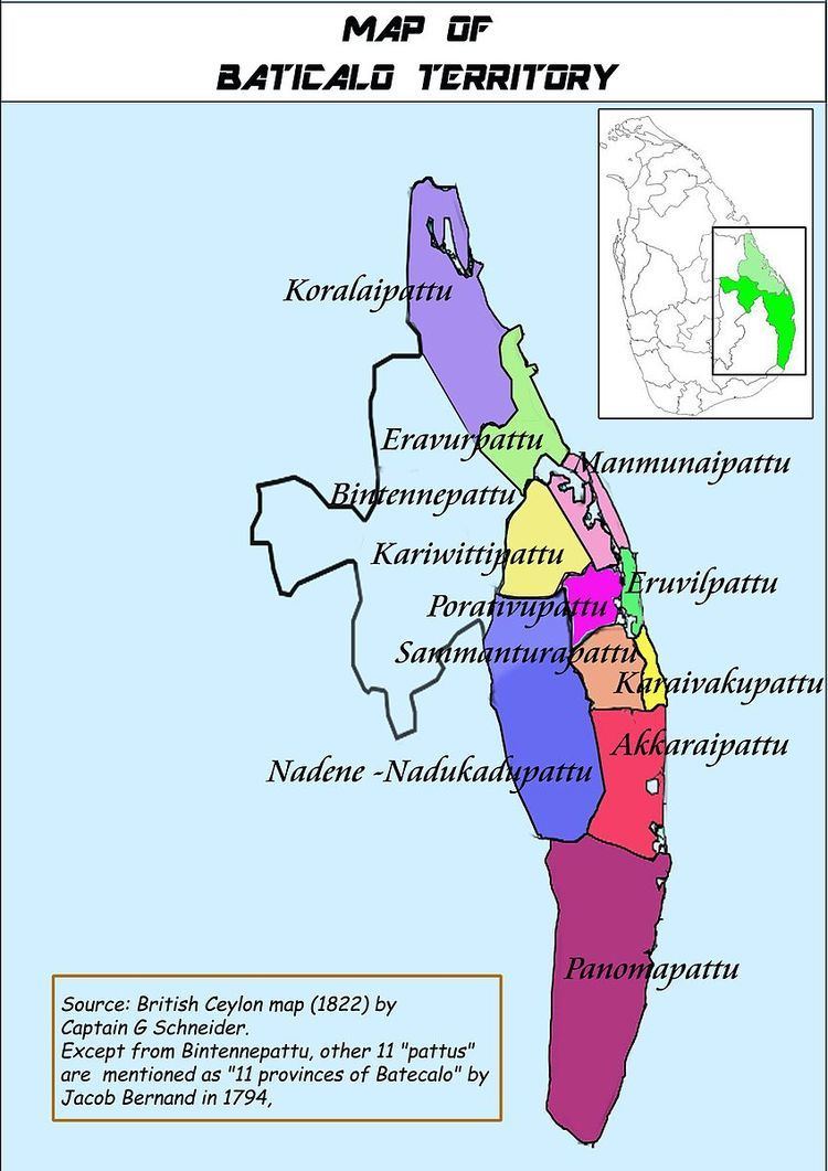
During the entrance of Portuguese to Ceylon, Batticaloa region was following Vannimai chieftainship same like Vanni region of northern Ceylon. There were three or four Vannian Chieftainships observed by the Portuguese historians like Bocarro and Queroz - Palugāmam, Panova and Sammanturai along with Eravur. By the end of the eighteenth century, the Dutch colonial territories comprised eleven separate sub-chieftaincies, or as dutch called them, "Provinces": seven Mukkuvar controlled districts of Eravur, Manmunai, Eruvil, Poraitivu, Karaivaku, Sammanturai and Akkaraipattu, plus Panama in the south, Nadu Kadu(or Nadene) in the west, and Koralai and Kariwitti to the north. totally eleven "provinces" were in Batticaloa territory.
Nāṭukāṭu Kalvettup Paravani and the Notes of Jacob Burnand indicates that Nadene or Nadukadu pattu (நாடுகாடுப் பற்று;Nāṭukāṭup paṟṟu) was joined as the last "Pattu" (Administrative division of Vannimais) with the ten other pattus of Batticaloa. But,Nadukadupattu was abandoned by its inhabitants soon and its residual populated area was later identified as "Wewgampattu" in later 19th century. In 1950s, there were nine D.R.O divisions (Divisional Revenue Officer Divisions - present Divisional secretariat Divisions) in Batticaloa District: Panamapattu, Akkaraipattu, Nintavur-Karaivakupattu, Sammanthuraipattu, Manmunaipattu North, Porativu - Manmunai South - Eruvilpattu, Bintennapattu, Eravur-Koralaipattu and Wewgampattu.
Bifurcation of the ancient territory
After the independence, Gal oya scheme was proposed by the Dominion of Ceylon to increase the rice productivity of South eastern part of the country in 1949 and it caused the creation of many settlements in the Nadukadupattu region within the end of that scheme in 1953. According to the new proposal of Electoral reforms in Ceylon in 1959, Nadukadu - Nadene pattus were introduced as a new electoral District with the name "Digamadulla" on 19.03.1960. At the end of 1960, Batticaloa District consists of four electoral districts in its southernmost part - Pottuvil, Kalmunai, Nintavur and Ampara.
However, The government of Ceylon declared a new administrative district including Pottuvil, Kalmunai and Ampara electoral districts on 10.04.1961. Ancient Batticaloa Territory was hereby divided into two administrative districts where the northern part remained in the same name,the southern part got a new name, "Amparai". According to the 1978 Constitution of Sri Lanka, the four single-member electoral districts of Ampara were replaced with one multi-member Digamadulla electoral district.
In divided Districts, pattu divisions of newly formed Batticaloa district still remains in the same name, though they disrupted to following Divisions in modern Ampara District.