
Country South Africa Area 73.5 km2 Founded 1820 | Language spoken Xhosa District Cacadu | |
 | ||
Map of Bathurst, Eastern Cape
Bathurst is about 12 kilometres (7.5 mi) inland from Port Alfred, on the R67 road, in the Eastern Cape province of South Africa. Its chief claim to fame is that it was the early administrative centre established by the British Government for the 1820 British Settlers who were sent to the district as a buffer between the Cape Colony and the Xhosa pastoralists who were migrating southwards and westwards along the coast. Bathurst is now part of the Ndlambe Local Municipality in the Sarah Baartman District Municipality of the Eastern Cape.
Contents
Bathurst eastern cape a small town in south africa
Overview
Many of the original settler houses and other buildings have been preserved, and there remains much of the look and feel of an English village of the early 19th Century. The Pig and Whistle Inn, at the heart of the village, is reputedly the oldest extant pub in the country. Built in 1821 by Thomas Hartley, a blacksmith who came from Nottinghamshire with the Settlers. Later accommodation was added and it became known as the Bathurst Inn. Legend has it that it was nicknamed "The Pig & Whistle" by the men at the nearby 43 Air School in World War II.
While time has moved slowly in Bathurst, there is an increasing population of artists, academics, Rhodes University is only 40 kilometres (25 mi) away, and retirees.
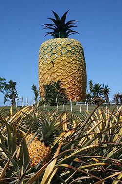
Bathurst hosts a pineapple museum whose building is shaped like a 17 metres (56 ft) tall pineapple.
Bathurst neighbours the Waters Meeting Nature Reserve, home to many species of animals, bird and plants. The reserve offers hiking trails, picnic spots and a remarkable viewpoint of the river and valley. The surrounding area hosts pineapple farms, game reserves and cattle and sheep ranches. It is a 10-minute drive to the beach town of Port Alfred and 45 minutes from the cultural mecca of Grahamstown.
The Horseshoe Bend and Water's Meeting Reserve: There is an outstanding view of bush covered valleys where the Kowie River loops in a horse shoe. Another 3 kilometres (1.9 mi) down a steep winding road you can picnic and relax under the trees at the waters edge. Canoe trails and scenic hikes available.
Bradshaw's Mill: Built by the Settler, Samuel Bradshaw in 1821, this water-driven wool mill contains a working water wheel. By 1825 wool from the Settlers sheep was being used to make coarse cloth. In 1835 the 3rd storey was added and corn milling began. It is now restored and is a provincial heritage site.
Wesleyan Chapel: Built by Samuel Bradshaw and opened in 1832, it was besieged in the Frontier Wars. Houses Jeremiah Goldswain's Family Bible. Services still held every Sunday. It is a provincial heritage site and epitomizes many of the other Wesleyan churches in the rural areas
St John's Anglican Church : The oldest unaltered Anglican church in South Africa. A sanctuary in the Frontier Wars of 1834, 1846 and 1851 for hundreds of Settlers. The first service in this church was held on 1 January 1838.
The Bathurst Agricultural Museum, established in 1970, hosts over 1300 items of farming equipment and accessories, including tractors and dairy utensils.
The Toposcope: This marks the spot from where the 1820 Settlers were posted to their locations by Jacob Glen Cuyler. Fifty-seven bronze plaques record details of settlements. On a clear day you can see from The Great Fish River to Kwaaihoek. The stones in the wall are taken from ruins of original Settler homes.