
Area 9.4 km² | Region Occitanie Intercommunality Piémont d'Alaric Local time Thursday 8:24 AM | |
 | ||
Weather 8°C, Wind W at 8 km/h, 86% Humidity | ||
Barbaira is a French commune in the Aude department in the Occitanie region of southern France.
Contents
- Map of 11800 Barbaira France
- Geography
- Administration
- Demography
- Industry
- Agriculture
- Civil heritage
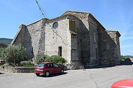
- Religious heritage
- Notable people linked to the commune
- References
Map of 11800 Barbaira, France
The inhabitants of the commune are known as Barbairanais or Barbairanaises.
Geography
Barbaira is located in the Corbières mountains at the foot of Mount Alaric in the urban area of Carcassonne some 15 km east of the city. Access to the commune is by the D6113 road from Floure in the west which passes through the north of the commune and the village before continuing east to Capendu. The A61 autoroute passes through the centre of the commune from west to east but there is no exit in the commune. The nearest exit is Exit 24 some 7 km to the west of the commune which links to the D6113. A railway passes through commune and the village from west to east but has no station in or near the commune. The commune is farmland in the north with the slopes of the mountain in the south forested.
The Aude river forms the northern border of the commune as it flows east to join the Mediterranean sea south-west of Valras-Plage. Several streams rise in the south of the commune and flow north to join the Aude including the Ruisseau de la Pelliere. The Ruisseau de Saint-Jean rises in the far south-east of the commune and flows north then east to join the Ruisseau de la Tuilerie.
Administration
List of Successive Mayors
(Not all data is known)
Demography
In 2010 the commune had 733 inhabitants. The evolution of the number of inhabitants is known from the population censuses conducted in the commune since 1793. From the 21st century, a census of communes with fewer than 10,000 inhabitants is held every five years, unlike larger communes that have a sample survey every year.
Sources : Ldh/EHESS/Cassini until 1962, INSEE database from 1968 (population without double counting and municipal population from 2006)
Industry
There is a Compressor station for the TIGF natural gas network.
Agriculture
The commune is part of the zone for the qualitative names: