
- elevation 10 m (33 ft) Area 1,739 km² | Founded 1881 Subdivisions 11 | |
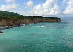 | ||
Points of interest San Rafael Beach, Polo Magnetico, Playa La Cienaga Destinations Polo, Barahona - Dominican Republic, Los Patos - Dominican Republic, Paraiso, Cabral - Dominican Republic | ||
Barahona ([baɾaˈona]) is a province of the Dominican Republic. The Barahona Coast is located on the southwestern part of the Dominican Republic approximately three hours drive from Santo Domingo the capital of the Dominican Republic.
Contents
Map of Barahona Province, Dominican Republic
Municipalities and municipal districts
The province as of June 20, 2006 is divided into the following municipalities (municipios) and municipal districts (distrito municipal - D.M.) within them:
The following is a sortable table of the municipalities and municipal districts with population figures as of the 2014 estimate. Urban population are those living in the seats (cabeceras literally heads) of municipalities or of municipal districts. Rural population are those living in the districts (Secciones literally sections) and neighborhoods (Parajes literally places) outside them. The population figures are from the 2014 population estimate.
For comparison with the municipalities and municipal districts of other provinces see the list of municipalities and municipal districts of the Dominican Republic.