
Population 1,141 (2011 Census) Post town SITTINGBOURNE Local time Thursday 3:56 AM Dialling code 01795 | Sovereign state United Kingdom Postcode district ME9 District Swale | |
 | ||
Weather 6°C, Wind W at 37 km/h, 61% Humidity | ||
Bapchild, is a village and civil parish in the Swale district of Kent, England, about two miles east of Sittingbourne. It lies on the old Roman road (Watling Street) now the A2, and according to the 2001 census, the parish had a population of 1,068, including Tonge and increasing to 1,141 at the 2011 Census.
Map of Bapchild, Sittingbourne, UK
According to Edward Hasted in 1800, it was anciently written 'Beccanceld' which is Old English for 'moist and bleak' and was mostly a marshland.
According to a late seventh or early eighth century charter, the Synod of Baccanceld was held in Bapchild, but historians now believe that the charter is a forgery.
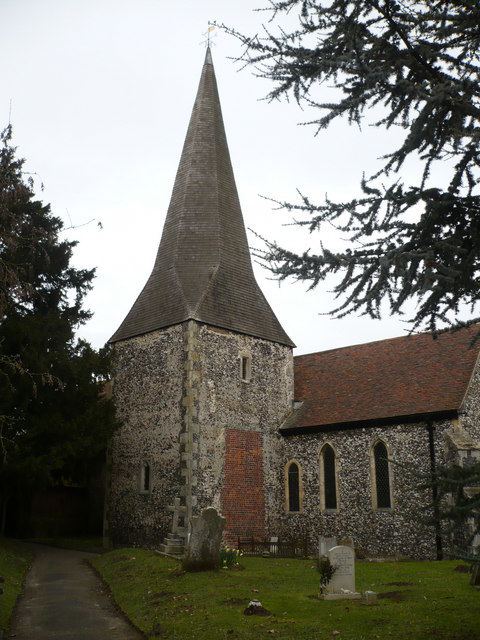
The village has its own church, the Grade I listed 'Church of St Lawrence'. Which is in the diocese of Canterbury, i in Kent, and deanery of Sittingbourne.
Other listed buildings in the parish include, the former post office, No 35, The Street (on the A2 road), and No 1, School Lane
Bapchild was also on the planned extension of the Swale Way (a bypass route, called the 'Sittingbourne Northern Relief road' (which was built in 2010/11)), which passes over the Milton Creek heads from the A249 road (past Kemsley) towards the Eurolink Industrial estate in Murston and then towards the East Hall Farm residential development. Plans were to extend it, over the railway to Bapchild, and onwards to the Kent Science Park near Highsted, before joining the M2 Motorway. But these have been put on hold due to cost and planning issues.