 | ||
Banswara District has an area of 5,037 km2, 1.47% of Rajasthan State, India. The city of Banswara is the district headquarters. It is bounded on the north by Udaipur District, on the northeast by Pratapgarh District, on the east and southeast by Madhya Pradesh state, on the southwest by Gujarat state, and on the west by Dungarpur District.
Contents
Map of Banswara, Rajasthan
Origin of name
The district is named after the former Princely State of Banswara. There are two traditions regarding the etymology of Banswara. According to one tradition, it is derived from the name of the Bhil chief Bansia who ruled over this area before being killed by Maharaval Jagmal Singh in 1529 CE. According to the other tradition, the name is derived from the Bans Vara (the country of bamboos) due to the abundance of bamboos in the dense forests of this region.
Geography
Banswara is part of the Vagad region of southern Rajasthan, which includes Banswara and Dungarpur districts. The region is mainly inhabited by tribals, predominantly Bhils. Banswara and Dungarpur are combinely called VAGAR, and in both the places local language is VAGRI.
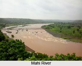
The District lies in the Mahi River basin. The Mahi flows north through the district from its origin in the Vindhya Range of Madhya Pradesh, entering the district from the southeast and flowing north towards the northern end of the district, where it turns southwest to form the boundary between Banswara and Dungarpur districts before entering Gujarat and emptying into the Gulf of Cambay.
Banswara District has rich flora and fauna. The forests include mainly teak. The wildlife includes a large variety of wild animals like leopard, chinkara, etc. Common birds in the region are fowl, partridge, black drongo, grey shrike, green bee-eater, bulbul, parrot etc.
Economy
In 2006 the Ministry of Panchayati Raj named Banswara one of the country's 250 most backward districts (out of a total of 640). It is one of the twelve districts in Rajasthan currently receiving funds from the Backward Regions Grant Fund Programme (BRGF).
Divisions
Banswara district is divided into 3 sub-divisions, which are further divided into 8 tehsils and 8 development blocks. Banswara sub-division consists Banswara and Garhi tehsils, Ghatol sub-division consists Ghatol tehsil and Kushalgarh sub-division consists Kushalgarh and Bagidora tehsils. The 8 development blocks in the district are: Talwara, Garhi, Ghatol, Peepal Khunt, Bagidora, Anandpuri, Kushalgarh and Sajjangarh.
The district consists 5 Vidhan Sabha constituencies, Kushalgarh, Danpur, Ghatol, Banswara and Bagidora. All of them along with 3 other Vidhan Sabha constituencies from Dungarpur district are part of the lone Lok Sabha constituency of the district, Banswara.
Demographics
According to the 2011 census Banswara district has a population of 1,798,194, roughly equal to the nation of The Gambia or the US state of Nebraska. This gives it a ranking of 267th in India (out of a total of 640). The district has a population density of 399 inhabitants per square kilometre (1,030/sq mi) . Its population growth rate over the decade 2001-2011 was 26.58%. Banswara has a sex ratio of 979 females for every 1000 males, and a literacy rate of 57.2%.
