
Intercommunality Pays de Jalès Area 32.68 km² | Canton Vans Population (2010) 687 Local time Thursday 2:34 AM | |
 | ||
Weather 7°C, Wind NW at 5 km/h, 86% Humidity | ||
Banne is a French commune in the Ardèche department in the Auvergne-Rhône-Alpes region of southern France.
Contents
- Map of 07460 Banne France
- Geography
- History
- Administration
- Demography
- Festivities and events
- Sites and Monuments
- Environmental heritage
- Notable people linked to the commune
- References
Map of 07460 Banne, France
The inhabitants of the commune are known as Bannards or Bannardes.
Geography
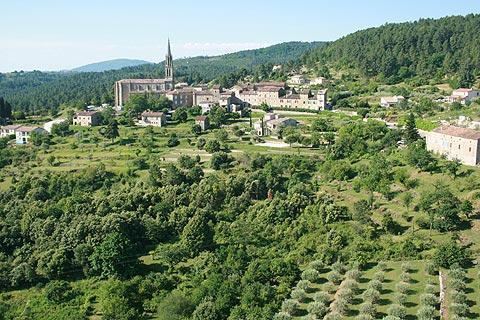
Banne is located some 32 km north by north-east of Alès and 40 km south by south-west of Aubenas. The southern border of the western arm of the commune is the departmental border between Ardèche and Gard. The village is at the top of a hill and seems cut in half with Le Fort to the north and L'Eglise to the south and a tangle of streets, stairways, and terraced gardens. It is an old mining town with coal deposits of high quality coke.
Access to the commune is by the D901 from Les Vans in the north which passes through the heart of the commune east of the village and continues south to Saint-Paul-le-Jeune. The D104 branches off the D901 in the south of the commune and goes north-east to Berrias-et-Casteljau. The D310 comes from the south and passes along the western edge of the commune to join the D216 to Les Vans just north of the commune. Access to the village is by the D251 from Saint-Paul-le-Jeune which continues to join the D310 in the commune. There are many hamlets in the commune apart from the village:
There is an area of farmland east of the village with most of the commune being forested.
The Granzon river rises in the north of the commune and flows east forming the northern border of the commune before turning south-east then east through the commune and continuing east to join the Chassezac near Maison Neuve. Several tributaries of the Granzon rise in the commune and flow northwards to join it including the Ruisseau de Doulovy, the Ruisseau de la Combe, the Ruisseau de l'Oulette, the Ruisseau de la Vernadelle, the Ruisseau de la Sauzède, and the Ruisseau de Claveysson.
The climate is of Mediterranean type.
History
During the French Revolution Count François-Louis de Saillans (1742-1792) attempted a royalist counter-revolution (the 3rd Camp de Jalès) with about 6,600 peasants. He captured Fort Banne in early July 1792. It was rapidly retaken by the General of Albignac who came to Bourgoin. A fire was started by the fighting which reduced the fort to ruins.
The French Revolution of 1848 was welcome in Banne and some of the inhabitants took the opportunity to challenge their mayor and ask for his revokaction by petition to the government commissioner. According to them he was protected by a former MP but he was actually part of a clique led by an opponent of Bayle and far from being motivated by republican ideals.
Until the mid-20th century several coal deposits were exploited in Banne with four concessions at: Montgros, Doulovy, Sallefermouse, and Pigère-Mazel. Together with Nieigles (today Lalevade-d'Ardèche), they were the only coal mines in Ardèche department. Since the closure of the mines forest has taken over the area (Bois des Bartres). Few traces of the mines remain except the magnificent Doulovy viaduct which was built in 1876. These deposits were the continuation of the Alès mining basin.
On 29 July 1944 several companies of maquisards decimated a German column who were marching to the north at the "Battle of Banne".
In 2008 the film Le Missionnaire was shot largely in the village. This was a film produced by Luc Besson , directed by Roger Delattre with Jean-Marie Bigard in the title role.
Administration
List of Successive Mayors
(Not all data is known)
Demography
In 2010 the commune had 687 inhabitants. The evolution of the number of inhabitants is known from the population censuses conducted in the commune since 1793. From the 21st century, a census of communes with fewer than 10,000 inhabitants is held every five years, unlike larger communes that have a sample survey every year.
Sources : Ldh/EHESS/Cassini until 1962, INSEE database from 1968 (population without double counting and municipal population from 2006)
Festivities and events
The Votive festival of Banne is held each year on the first weekend of August. This festival usually takes place over three days and is organized by the festival committee of Banne (CBF). It begins on Friday evening with a ball then continues on Saturday afternoon with petanque competitions and, in the evening, a grand ball. Finally on Sunday afternoon a goat trifecta is run to end up with a big meal in the evening.
Sites and Monuments
Environmental heritage
Several places are classified as natural areas of ecological interest, flora and fauna: