
Country Thailand Postal code 77140 Area 868 km² | Time zone ICT (UTC+7) Geocode 7704 | |
 | ||
Province Prachuap Khiri Khan Province | ||
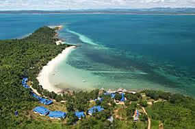
Flooding at our beach bang saphan december 6th 2016
Bang Saphan or Bangsaphan (Thai: บางสะพาน) is a district (amphoe) in the southern part of Prachuap Khiri Khan Province, central Thailand.
Contents
- Flooding at our beach bang saphan december 6th 2016
- Map of Bang Saphan District Prachuap Khiri Khan Thailand
- History
- Geography
- Administration
- References
Map of Bang Saphan District, Prachuap Khiri Khan, Thailand
History
Bang Saphan was an ancient city since Ayutthaya Kingdom. In Thonburi Kingdom, it was named Mueang Kamnoed Nopphakhun. King Nangklao (Rama III) of Rattanakosin set Kamnoed Nopphakhun to be a fourth-class city under the Kalahom (defence ministry). King Chulalongkorn (Rama V) downgraded the city to be Mueang Kamnoed Nopphakhun District. In 1915 King Vajiravudh (Rama VI) renamed the district by cutting the word Mueang off. Later the king changed the name to be Bang Saphan.
Geography
Amphoe Bang Saphan's neighboring districts are Thap Sakae to the north and Bang Saphan Noi to the south. To the west are the Tenasserim Hills and the Tanintharyi Division of Myanmar, to the east the Gulf of Thailand.
Administration
The district is divided into seven sub-districts (tambon), which are further subdivided into 71 villages (muban). There are three townships (thesaban tambon) areas: Kamnoet Nopphakhun covers parts of tambon Kamnoet Nopphakhun, Ronthong covers part of tambon Ronthong, and Ban Krut covers parts of tambon Thongchai. There are a further seven tambon administrative organizations (TAO) responsible for the non-municipal areas.