
Country Thailand Tambon 3 Postal code 10540 Area 114.8 km² Province Samut Prakan Province | Seat Bang Sao Thong Time zone THA (UTC+7) Geocode 1106 Population 75,727 (2015) | |
 | ||
Bang Sao Thong (Thai: บางเสาธง; [bāːŋ sǎw tʰōŋ]) is a district (Amphoe) of Samut Prakan Province in central Thailand.
Contents
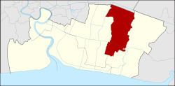
Map of Bang Sao Thong District, Samut Prakan, Thailand
Geography
Neighboring districts are Lat Krabang (Bangkok) to the North, Bang Bo to the East and Bang Phli to the West.
History
Bang Phli New Town (Thai Mueang Mai Bang Phli) was established between 1992 to 1993 as a residential area for high-income families. The area around the new town comprising three tambon was then split off from Bang Phli district and formed the new minor district (King Amphoe), becoming effective on April 1, 1995.
The new town covers about 20,000 homes and can hold more than 100,000 people. There is also a complex of public facilities directly east of the town. Across the Bang Phli New Town Road east of these facilities are office buildings.
Following a decision of the Thai government on May 15, 2007, all of the 81 minor districts were to be upgraded to full districts. With the publishing in the Royal Gazette on August 24 the upgrade became official .
Administration
The district is subdivided into 3 subdistricts (tambon), which are further subdivided into 39 villages (muban). Bang Sao Thong is a township (thesaban tambon) which covers parts of tambon Bang Sao Thong and Sisa Chorakhe Yai. Each of the tambon has a Tambon administrative organization (TAO) responsible for the non-municipal area.