
Country Thailand Muban 159 Time zone ICT (UTC+7) Area 923.8 km² Province Udon Thani Province | Tambon 13 Amphoe established 1959 Postal code 41190 Population 124,812 (2013) | |
 | ||
Ban Dung (Thai: บ้านดุง) is a district (amphoe) in northeastern Udon Thani Province, northeastern Thailand.
Contents
- Map of Ban Dung District Udon Thani Thailand
- Geography
- History
- Central administration
- Local administration
- Central government services
- State enterprises and organizations
- Education
- Religion
- Media
- Economy
- Farming
- Retail
- OTOP
- Salt production
- Places of interest
- Transportation
- Buses
- References
Map of Ban Dung District, Udon Thani, Thailand
Geography
Neighboring districts are (from the south clockwise) Thung Fon, Phibun Rak, Phen, and Sang Khom of Udon Thani Province, Phon Phisai and Fao Rai of Nong Khai Province, and Ban Muang, Charoen Sin, and Sawang Daen Din of Sakon Nakhon Province.
North of Ban Dung are marshlands and open water called Nong Pla Tao.
The major river is the Songkhram, which marks the boundary of the district to the east.
History
The minor district (king amphoe) Ban Dung was established on 16 May 1959, when three sub-districts were split off from Nong Han district. It was upgraded to a full district on 16 July 1963.
Central administration
The district Ban Dung is divided into 13 sub-districts (tambon), which are further divided into 159 administrative villages (muban).
Local administration
There is one town (Thesaban Mueang) in the district:
There are 12 sub-district administrative organizations (SAO) in the district:
Central government services
State enterprises and organizations
Education
Religion
As in the rest of Thailand, the population is almost exclusively Theravada Buddhist, although this is combined with elements of animism and in rural areas there are pockets of Christianity. Overall within the district 91.13 percent are Buddhist with Catholics representing 8.87 percent. Within the amphoe there are 104 Buddhist temples and seven Catholic churches in the villages of Phon Sung, Ban Thung Kwang Patana, Ban Non Sombun, Ban Pak Dong, Sri Wattana, and Sri Sut Tho and one Protestant church, also in Sri Sut Tho.
Media
In common with many other districts Ban Dung has its own local radio station which broadcasts on FM 103 MHz. All broadcasts are in Thai.
Economy
The average income per year in Ban Dung was 42,023 baht per person in 2011 with the majority of people being farmers. However, there is an increasing number of people employed in the retail and building trades as the town continues to increase in size with a steady influx of people moving into Ban Dung including a significant number of expats and their spouses.
Farming
The major crop grown is rice with 259,066 rai being cultivated by 13,708 people out of a total farming area of 327,480 rai. There was also 15,667 rai of rubber under cultivation, 550 rai of palm oil, and 1,445 rai used for rock salt extraction. Other crops included maize, cassava, eucalyptus, sugar cane and various fruit and vegetables. Other farming activities included the rearing of buffalo, cattle, pigs, and chickens with a small number of people raising fish in lakes or ponds.
Water buffalo are a regular feature being walked to and from the fields at dawn and dusk. Although rarely used nowadays for working the land, they are considered an important status symbol.
Retail
The retail sector plays a large part in the local economy and in addition to its two large markets Ban Dung also has two Tesco Lotuss, four 7-Elevens, nine gold shops, seven motorcycle retail outlets, two car showrooms, 11 karaoke bars, five hotels, and over twenty resort hotels. It also has many other shops ranging from Internet cafes and farang bars to agricultural supplies.
OTOP
There are various products produced in the tambons under the OTOP (One Tambon One Product) scheme. These include textile dyeing, silk weaving, knitwear products, woven reed mats, mattress and pillows, woven blankets, shampoo, and local herbs.
Salt production
The salt making area around Ban Dung has produced salt for industrial purposes for more than 25 years. The production method used as in many other places in northeast Thailand is called solution mining. The mining is done by local co-operative groups.
Refined salt for domestic use is made by evaporating salt water in large open vats using ovens with rice husks used as the fuel source. This method produces very clean, fine grained salt in which the impurities are removed during cooking. Traditionally, the stove used in salt making was wood-fueled. Wood became more expensive, prompting a shift to rice hull stoves. The abundance of rice hulls has made it economically feasible to reprocess the salt and is a renewable source of fuel. The residue, rice hull ash, (RHA) is then sold back to farmers for use as fertilizer.
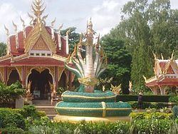
Places of interest
Transportation
The town is adjacent to the intersection of Highway 2022 and Highway 2096.
Buses
Essential local services are provided by songthaew truck and pickup truck buses, while regional and long distance destinations are served by regular buses from Udon Thani.
There are two main public buses. Both start at the central bus station in Udon Thani. One bus route goes via Highway 22 and then turns left at Nong Mek along Highway 2096 to Ban Dung (Kham Takla bus route). The other bus route goes via Highway 2 before turning right at Ban Na Kha along Highway 2256 to the Sum Sao intersection and then along Highway 2022 to Ban Dung (Bueng Kan Bus route). Both run at regular intervals.
Long-distance VIP buses operate from opposite the police station and run nightly to Bangkok. There are also direct night buses to and from Pattaya.